Back Baker-eiland Afrikaans جزيرة بيكر Arabic جزيره بيكر ARZ Beyker adası Azerbaijani بیکر آداسی AZB Бэйкер Byelorussian Бэйкер BE-X-OLD Бейкър (остров) Bulgarian বেকার দ্বীপ Bengali/Bangla Ostrvo Baker BS
| Bakerinsl | |
|---|---|
 | |
| Gwassa | Pazifischa Ozean |
| Geographische Log | 0° 11′ 42″ N, 176° 28′ 42″ W |
 | |
| Leng | 2 km |
| Broadn | 1 km |
| Flechn | 1,64 km² |
| Hechsta Beag | 8 m |
| Eiwohna | (unbewohnt) |
| Haptort | Meyerton (historisch) |
 | |
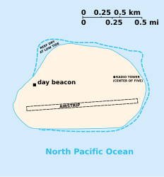
De Bakerinsl (engl. Baker Island), is a kloane, unbewohnte Insl im Pazifik, de wo zu de Aussngebiet vo da USA gheat. Es is a sognennts ned inkorporiats Territorium. De Insl is aa zamm mit da Howlandinsel de oanzige Londfläch mit da Zeitzone UTC-12 (International Date Line West, IDLW).
© MMXXIII Rich X Search. We shall prevail. All rights reserved. Rich X Search