Back كرنول Arabic كرنول (كرنول) ARZ کورنوول AZB कर्नूल Bihari কর্নুল Bengali/Bangla কুর্নল BPY Kurnool Catalan Kurnool (lungsod) CEB Kurnool German Kurnul Esperanto
Kurnool
Kandanavōlu (Kandanōlu) | |
|---|---|
City | |
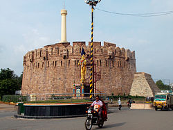
Clockwise from top: Skyline of Kurnool from Penna River Bridge, Pumphouse road in Kurnool, Kurnool Railway station, Kurnool City from Jagannatha Gattu and Kondareddy Buruju | |
| Nickname: The Gateway of Rayalaseema | |
 Interactive map | |
| Coordinates: 15°50′N 78°03′E / 15.83°N 78.05°E | |
| Country | |
| State | Andhra Pradesh |
| Region | Rayalaseema |
| District | Kurnool |
| Government | |
| • Type | Municipal corporation |
| • Body | Kurnool Municipal Corporation |
| • Mayor | B Y Ramaiah (YSRCP) |
| • MLA | T. G. Bharath |
| • MP | Bastipati Nagaraju Panchalingala |
| Area | |
• City | 129.2 km2 (49.9 sq mi) |
| • Rank | 107 |
| Elevation | 274 m (899 ft) |
| Population (2011)[2] | |
• City | 425,214 |
| • Rank | 109th (India) 5th (Andhra Pradesh) |
| • Density | 3,300/km2 (8,500/sq mi) |
| • Metro | 484,327 |
| Demonym | Kurnoolian |
| Languages | |
| • Official | Telugu |
| Time zone | UTC+5:30 (IST) |
| PIN | 518001, 518002, 518003, 518004, 518005, 518006, 518007 |
| Vehicle registration | AP-21[4] |
| Website | Kurnool Municipal Corporation |
Kurnool is a city in the state of Andhra Pradesh, India. It formerly served as the capital of Andhra State (1953–1956).[5][6][7] The city is often referred to as "The Gateway of Rayalaseema". Kurnool is also famous for Diamond hunting as diamonds can be found in the barren land of Kurnool after the top layers of soil are washed away by the monsoon rains.[8] It also serves as the district headquarters of its Kurnool district. As of 2011[update] census, it is the fifth most populous city in the state with a population of 484,327.[3][9] It is located on the banks of the Tungabhadra river. Although the area has been inhabited for thousands of years, modern Kurnool was founded in the 16th century CE with the construction of the Konda Reddy Fort.
- ^ "Kurnool Municipal Corporation |". kurnool.cdma.ap.gov.in. Archived from the original on 3 December 2019. Retrieved 29 October 2017.
- ^ "Cities having population 1 lakh and above, Census 2011" (PDF). Office of the Registrar General & Census Commissioner, India. Retrieved 29 May 2021.
- ^ a b "Urban Agglomerations/Cities having population 1 lakh and above" (PDF). Office of the Registrar General & Census Commissioner, India. Retrieved 29 May 2021.
- ^ "Registration | District Codes | Transport Department Government of Andhra Pradesh – India". aptransport.org.
- ^ Gopi Dara (22 November 2021). "AP Capital News: Andhra Pradesh govt withdraws three-capitals bills | Vijayawada News - Times of India". The Times of India. Retrieved 22 November 2021.
- ^ "Andhra Pradesh high court orders status quo on two new laws for three capitals". TOI. 4 August 2020.
- ^ "Andhra Governor gives nod to CM Jagan Mohan Reddy's three-capital plan". Livemint. 1 August 2020. Retrieved 2 August 2020.
- ^ "Diamond hunters descend on Kurnool as monsoon hits AP". The Times of India. ISSN 0971-8257. Retrieved 17 June 2024.
- ^ "Andhra Pradesh (India): Districts, Cities and Towns - Population Statistics, Charts and Map". www.citypopulation.de. Retrieved 17 April 2020.
© MMXXIII Rich X Search. We shall prevail. All rights reserved. Rich X Search


