Back Donegalscīr ANG مقاطعة دونيجال Arabic Condáu de Donegal AST Донигал (графство) Bulgarian Kontelezh Dún na nGall Breton Comtat de Donegal Catalan County Donegal CEB Hrabství Donegal Czech Swydd Donegal Welsh County Donegal Danish
| Karte | |
|---|---|
 | |
| Basisdaten | |
| Staat: | Irland |
| Verwaltungssitz: | Lifford |
| Provinz: | Ulster |
| irischer Name: | Dún na nGall |
| Fläche: | 4860 km² |
| Einwohner: | 167.084 (2022)[1] |
| Kfz-Kennzeichen: | DL |


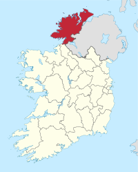
Donegal (), (irisch Dún na nGall, ()), ist ein County im Norden der Republik Irland in der Region Ulster. Es ist nach der in ihr gelegenen gleichnamigen Stadt benannt. Donegal ist eine von drei Grafschaften, die in der ehemaligen Provinz Ulster liegen, aber seit 1921 der Republik Irland und nicht Nordirland angehören.
- ↑ Census of Population 2022 - Summary Results. Central Statistics Office Ireland (Stand 2022).
© MMXXIII Rich X Search. We shall prevail. All rights reserved. Rich X Search