Back Avenida New Utrecht (línea Sea Beach) Spanish New Utrecht Avenue/62nd Street Italian 62丁目/ニュー・ユトレヒト・アベニュー駅 Japanese New Utrecht Avenue / 62nd Street (metrostation) Dutch New Utrecht Avenue / 62nd Street Polish Нью-Ютрект-авеню / 62-я улица (Нью-Йоркское метро) Russian 62街/新烏德勒支大道車站 Chinese
62 Street/New Utrecht Avenue | |||||||||||
|---|---|---|---|---|---|---|---|---|---|---|---|
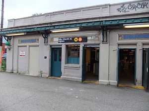
 The station's main headhouse prior to renovation | |||||||||||
| Station statistics | |||||||||||
| Address | New Utrecht Avenue & 62nd Street Brooklyn, NY | ||||||||||
| Borough | Brooklyn | ||||||||||
| Locale | Bensonhurst, Borough Park | ||||||||||
| Coordinates | 40°37′34″N 73°59′52″W / 40.626086°N 73.997887°W | ||||||||||
| Division | B (BMT)[1] | ||||||||||
| Line | BMT Sea Beach Line BMT West End Line | ||||||||||
| Services | D N W | ||||||||||
| Transit | |||||||||||
| Levels | 2 | ||||||||||
| Other information | |||||||||||
| Accessible | |||||||||||
| Traffic | |||||||||||
| 2023 | 1,201,167[3] | ||||||||||
| Rank | 257 out of 423[3] | ||||||||||
| |||||||||||
| |||||||||||
| |||||||||||
The 62nd Street/New Utrecht Avenue station is a New York City Subway station complex shared by the open-cut BMT Sea Beach Line and the elevated BMT West End Line. It is located at New Utrecht Avenue and 62nd Street in Borough Park and Bensonhurst, Brooklyn, and is served by the D and N trains at all times. During rush hours, several W trains also serve this station.
Prior to the rebuilding of the two current subway lines at this location during the 1910s, this location was known as Bath Junction. Until then, there was a track connection between the lines, primarily to enable Sea Beach trains to and from Coney Island to access West End Line trackage to reach the Brooklyn Bridge and the Park Row Terminal in Lower Manhattan. From 2016 to 2019, the complex underwent an extensive renovation.
- ^ "Glossary". Second Avenue Subway Supplemental Draft Environmental Impact Statement (SDEIS) (PDF). Vol. 1. Metropolitan Transportation Authority. March 4, 2003. pp. 1–2. Archived from the original (PDF) on February 26, 2021. Retrieved January 1, 2021.
- ^ "Brooklyn Bus Map" (PDF). Metropolitan Transportation Authority. October 2020. Retrieved December 1, 2020.
- ^ a b "Annual Subway Ridership (2018–2023)". Metropolitan Transportation Authority. 2023. Retrieved April 20, 2024.
© MMXXIII Rich X Search. We shall prevail. All rights reserved. Rich X Search


