Back نهر أدا Arabic نهر ادا ARZ Adda çayı Azerbaijani Ада (рака) Byelorussian Ада (рака) BE-X-OLD Ада (река) Bulgarian Stêr Adda Breton Adda Catalan Fiume Adda CEB Adda Czech
| Adda | |
|---|---|
 The Adda in Imbersago | |
 Location of the Adda | |
| Location | |
| Countries | Italy, Switzerland |
| Physical characteristics | |
| Source | Val Alpisella[1] |
| • location | east of Livigno, Italy |
| • coordinates | 46°32′50.64″N 10°14′21.12″E / 46.5474000°N 10.2392000°E |
| • elevation | 2,122 m (6,962 ft) |
| Mouth | Po |
• coordinates | 45°08′04″N 9°52′54″E / 45.13444°N 9.88167°E |
| Length | 313 km (194 mi) |
| Basin size | 7,979 km2 (3,081 sq mi) |
| Discharge | |
| • average | 187 m3/s (6,600 cu ft/s) |
| Basin features | |
| Progression | Po→ Adriatic Sea |
| Tributaries | |
| • left | Brembo Serio |
| • right | Mallero Mera |
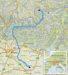
The Adda (Latin: Abdua, or Addua; Lombard: Ada or, again, Adda in local dialects where the double consonants are marked) is a river in North Italy, a tributary of the Po. It rises in the Alps near the border with Switzerland and flows through Lake Como. The Adda joins the Po a few kilometres upstream of Cremona. It is 313 kilometres (194 mi) long. The highest point of the drainage basin is the summit of la Spedla (a subpeak of Piz Bernina), at 4,020 metres (13,190 ft).
Towns along the river Adda include Bormio, Tirano, Sondrio, Bellagio and Lecco (both on Lake Como), Brivio and Lodi. One tributary, the Poschiavino, arises in Switzerland and runs through the town of Poschiavo.
- ^ "Cartello sorgente dell'adda 2122 m" (in Italian).
© MMXXIII Rich X Search. We shall prevail. All rights reserved. Rich X Search