Back Agulhasbank Afrikaans Banc Agulhas Catalan Banco di Agulhas Italian アガラスバンク Japanese აგულიასის ქვაბული Georgian Aguljaso dubuma Lithuanian Agulhasbank Dutch Banco das Agulhas Portuguese Агульяс (банка) Ukrainian Agulyas (soylik) Uzbek
| Agulhas Bank | |
|---|---|
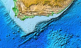
 Map of the Agulhas Bank centred on the Outeniqua Basin | |
| Ecology | |
| Realm | Temperate Southern Africa |
| Geography | |
| Area | 116,000 km2 (45,000 sq mi) |
| Country | South Africa |
| Elevation | -50 to -200 m |
| Coordinates | 34°42′33.1″S 22°28′12.4″E / 34.709194°S 22.470111°E |
| Oceans or seas | Atlantic Ocean, Indian Ocean |
The Agulhas Bank (/əˈɡʌləs/, from Portuguese for Cape Agulhas, Cabo das Agulhas, "Cape of Needles")[1] is a broad, shallow part of the southern African continental shelf which extends up to 250 km (160 mi) south of Cape Agulhas before falling steeply to the abyssal plain.
It is the ocean region where the warm Indian Ocean and the cold Atlantic Ocean meet. This convergence leads to treacherous sailing conditions, accounting for numerous wrecked ships in the area over the years. However, the meeting of the oceans here also fuels the nutrient cycle for marine life, making it one of the best fishing grounds in South Africa.
© MMXXIII Rich X Search. We shall prevail. All rights reserved. Rich X Search