Back Islles Aleipata AST Aleipata-Inseln German Islas Aleipata Spanish Illas Aleipata Galician Aleipatos salos Lithuanian Aleipata-eilanden Dutch Алеипата Russian Aleipata Islands Slovak Motu i Aleipata Samoan Aleipataöarna Swedish
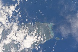
 Aleipata islands east of Upolu island (NASA) | |
 | |
| Geography | |
|---|---|
| Coordinates | 14°04′20″S 171°24′40″W / 14.07222°S 171.41111°W |
| Area | 1.7 km2 (0.66 sq mi) |
| Highest elevation | 180 m (590 ft) |
| Administration | |
| Demographics | |
| Population | Uninhabited |
The Aleipata Islands are a group of four uninhabited islands off the eastern end of Upolu Island, Samoa, in central South Pacific Ocean. The islands are eroded volcanic tuff rings, and consist of a small northern pair on Upolu's barrier reef, and a larger southern pair outside it.[1] Collectively the islands have an area of about 1.7 km2 (0.66 sq mi).[2] Administratively, the islands are part of the Atua district. The islands are important for Samoa's biodiversity and are protected by the Aleipata Marine Protected Area.[3]
- ^ "Aleipata Islands". OceanDots.com. Archived from the original on 2010-12-23. Retrieved 2009-03-14.
- ^ Whistler, W. Arthur (1983). "Vegetation and Flora of the Aleipata Islands, Western Samoa" (PDF). Pacific Science. 37 (3): 227–249. Retrieved 17 August 2021.
- ^ "Community Integrated Management Plan: Aleipata-Itupa I Luga - Upolu" (PDF). Ministry of Natural Resources and Environment. 2018. p. 12. Retrieved 17 August 2021.
© MMXXIII Rich X Search. We shall prevail. All rights reserved. Rich X Search