Back Ambelau ACE أمبالاو Arabic امبالاو ARZ Ambelau Azerbaijani Ambelau BM Pulau Ambelau CEB Ambelau German Ambelau Spanish Ambelau Estonian Ambelau (île) French
Native name: Pulau Ambalau | |
|---|---|
 | |
| Geography | |
| Location | Southeast Asia |
| Coordinates | 3°51′20″S 127°11′30″E / 3.85556°S 127.19167°E |
| Archipelago | Greater Sunda Islands |
| Area | 306 km2 (118 sq mi) |
| Highest elevation | 608 m (1995 ft) |
| Highest point | Gunung Baula |
| Administration | |
| Province | Maluku |
| Regency | South Buru Regency |
| Largest settlement | Wailua |
| Demographics | |
| Population | 9225 (mid 2023 estimate) |
| Pop. density | 30.1/km2 (78/sq mi) |
| Languages | Ambelau language |
| Additional information | |
| Time zone | |

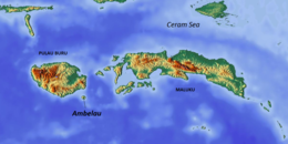
Ambelau or Ambalau is a volcanic island in the Banda Sea within Maluku Islands of Indonesia. The island forms an administrative district (Indonesian: Kecamatan Ambalau) which is part of the South Buru Regency (Indonesian: Kabupaten Buru Selatan) of Maluku province (Indonesian: Provinsi Maluku), Indonesia. It has a land area of 306 km2, and had a population of 6,846 at the 2010 Census;[1] the official estimate as at mid 2023 was 9,225.[2] The administrative center is Wailua, a settlement located at the south of the island. About half of the island's population is composed of indigenous Ambelau people who speak the Ambelau language; the other half are mostly immigrants from the nearby Maluku Islands and Java.
© MMXXIII Rich X Search. We shall prevail. All rights reserved. Rich X Search
