Back أميرشام (محطة مترو أنفاق لندن) Arabic Amersham (stanice metra v Londýně) Czech Bahnhof Amersham German ایستگاه امرشام Persian Amershamin asema Finnish Amersham (métro de Londres) French 阿摩閃站 GAN Amersham állomás Hungarian Stazione di Amersham Italian Stazion de Amersham LMO
| Amersham | |
|---|---|
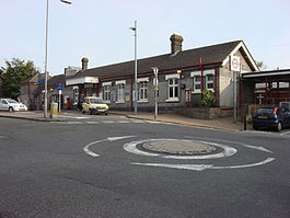
 Station entrance | |
| Location | Amersham |
| Local authority | Buckinghamshire |
| Managed by | London Underground[1] |
| Station code(s) | AMR |
| Number of platforms | 3 |
| Accessible | Yes[2] |
| Fare zone | 9 |
| London Underground annual entry and exit | |
| 2018 | |
| 2019 | |
| 2020 | |
| 2021 | |
| 2022 | |
| National Rail annual entry and exit | |
| 2018–19 | |
| 2019–20 | |
| 2020–21 | |
| 2021–22 | |
| 2022–23 | |
| Key dates | |
| 1892 | Opened |
| 4 July 1966 | Goods yard closed[9] |
| Other information | |
| External links | |
| Coordinates | 51°40′26″N 0°36′25″W / 51.674°N 0.607°W |
Amersham is a London Underground station in Amersham in the Chiltern district of Buckinghamshire, England which is also used by National Rail services.
Amersham station is a terminus of the London Underground's Metropolitan line.[2] It is 23.7 miles (38.1 km) northwest of Charing Cross, making it the second furthest Underground station from central London and the second most westerly station of the whole London Underground system, after Chesham.[10] It is in Travelcard Zone 9[2] (previously zone D).
The station has the highest elevation on the entire London Underground network at 147m above sea-level, higher than Big Ben tower.[11]
Amersham station is also served by Chiltern Railways, which runs trains between London Marylebone and Aylesbury. From Aylesbury a shuttle service to Princes Risborough provides access to through services between Marylebone and Birmingham Snow Hill. The journey times between Amersham and Central London range between 33 and 60 minutes. The journey time between Amersham and Chalfont & Latimer is about three and a half minutes.[12]
- ^ National Rail Enquiries – Station facilities for Amersham
- ^ a b c Standard Tube Map (PDF) (Map). Not to scale. Transport for London. April 2024. Archived (PDF) from the original on 28 May 2024. Retrieved 3 June 2024.
- ^ "Station Usage Data" (CSV). Usage Statistics for London Stations, 2018. Transport for London. 23 September 2020. Archived from the original on 14 January 2023. Retrieved 11 October 2023.
- ^ "Station Usage Data" (XLSX). Usage Statistics for London Stations, 2019. Transport for London. 23 September 2020. Archived from the original on 9 November 2020. Retrieved 9 November 2020.
- ^ "Station Usage Data" (XLSX). Usage Statistics for London Stations, 2020. Transport for London. 16 April 2021. Retrieved 1 January 2022.
- ^ "Station Usage Data" (XLSX). Usage Statistics for London Stations, 2021. Transport for London. 12 July 2022. Retrieved 7 September 2022.
- ^ "Station Usage Data" (XLSX). Usage Statistics for London Stations, 2022. Transport for London. 4 October 2023. Retrieved 10 October 2023.
- ^ a b c d e "Estimates of station usage". Rail statistics. Office of Rail Regulation. Please note: Some methodology may vary year on year.
- ^ Hardy, Brian, ed. (March 2011). "How it used to be – freight on The Underground 50 years ago". Underground News (591). London: London Underground Railway Society: 175–183. ISSN 0306-8617.
- ^ OpenStreetMap
- ^ "The London Underground station that's so high up it would tower over Big Ben". www.msn.com. Retrieved 29 June 2023.
- ^ "Tube Facts – Stations that it takes the longest to travel between". Archived from the original on 3 April 2015. Retrieved 29 March 2015.
© MMXXIII Rich X Search. We shall prevail. All rights reserved. Rich X Search
