Back عربي (لويزيانا) Arabic آرابی، لوئیزیانا AZB Arabi (Louisiana) Catalan Араби (Луизиана) CE Arabi (lungsod sa Tinipong Bansa, Louisiana) CEB Arabi (Luisiana) Spanish ارابی، لوئیزیانا Persian Arabi (Louisiane) French Arabi (Louisiana) Italian Arabi (Louisiana) LLD
Arabi, Louisiana | |
|---|---|
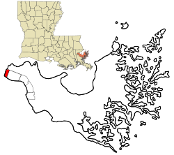
 Location in St. Bernard Parish and the state of Louisiana. | |
| Coordinates: 29°57′27″N 89°59′56″W / 29.95750°N 89.99889°W | |
| Country | United States |
| State | Louisiana |
| Parish | St. Bernard |
| Area | |
| • Total | 2.03 sq mi (5.26 km2) |
| • Land | 1.75 sq mi (4.55 km2) |
| • Water | 0.28 sq mi (0.71 km2) |
| Elevation | 3 ft (0.9 m) |
| Population (2020) | |
| • Total | 4,533 |
| • Density | 2,582.91/sq mi (997.30/km2) |
| Time zone | UTC-6 (CST) |
| • Summer (DST) | UTC-5 (CDT) |
| Zip Code | 70032 |
| Area code | 504 |
| FIPS code | 22-02550 |
Arabi (/ˈærəbi/)[2] is a census-designated place (CDP) in St. Bernard Parish, Louisiana, United States. It lies on the eastern bank of the Mississippi River, between the Lower 9th Ward of New Orleans and Chalmette within the Greater New Orleans metropolitan area. The population was 4,533 at the 2020 census.[3]
- ^ "2020 U.S. Gazetteer Files". United States Census Bureau. Retrieved March 20, 2022.
- ^ Rick Aschmann (May 2, 2018). "North American English Dialects, Based on Pronunciation Patterns". Aschmann.net. Retrieved November 25, 2019.
- ^ "2020 Race and Population Totals". United States Census Bureau. Archived from the original on October 23, 2021. Retrieved October 23, 2021.
© MMXXIII Rich X Search. We shall prevail. All rights reserved. Rich X Search