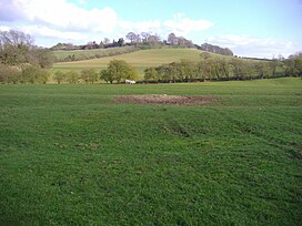
| Arbury Hill | |
|---|---|
 Arbury Hill from the west | |
| Highest point | |
| Elevation | 225 m (738 ft)[1] |
| Listing | County top |
| Coordinates | 52°13′27″N 1°12′36″W / 52.2243°N 1.2101°W |
| Geography | |
| Location | Northamptonshire, England |
| OS grid | SP540587 |
| Topo map | OS Explorer 206 |
Arbury Hill, at 225 m (738 ft), is the joint highest point in the English county of Northamptonshire.[1][2] It is 9 km (5.6 mi) southwest of the town of Daventry.
The slopes of Arbury Hill are a drainage divide between three major river catchment areas, with the Nene to the north, east and south, the Cherwell (a tributary of the Thames) to the south-west and the Leam (a tributary of the Severn) to the west and north-west.[2] There are fine views with Rugby and Coventry visible to the northwest and Northampton to the east. The River Nene rises in a swampy hollow on the northwestern flanks of the hill.[3]
- ^ a b Bathurst, David (2012). Walking the county high points of England. Chichester: Summersdale. pp. 56–59. ISBN 978-1-84-953239-6.
- ^ a b OS Explorer Map 207: Newport Pagnell & Northampton South (1:25 000) ISBN 0319 46387 7
- ^ Cite error: The named reference
JMwas invoked but never defined (see the help page).
© MMXXIII Rich X Search. We shall prevail. All rights reserved. Rich X Search

