Back Serralada Àrtica Catalan Arktische Kordillere German Arkta montoĉeno Esperanto Cordillera Ártica Spanish Mendikate Artikoa Basque Cordillère Arctique French הקורדילרה הארקטית HE Cordigliera Artica Italian Arctic Cordillera LLD Arctische Cordillera Dutch
| Arctic Cordillera | |
|---|---|
 Baffin Mountains ecoregion of the Arctic Cordillera | |
 | |
| Ecology | |
| Borders | |
| Geography | |
| Area | 242,190 km2 (93,510 sq mi) |
| Country | Canada |
| Provinces | |
| Coordinates | 81°56′N 74°54′W / 81.93°N 74.90°W |
| Climate type | Polar and Ice cap |
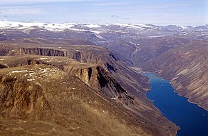
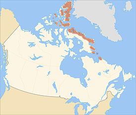
The Arctic Cordillera is a terrestrial ecozone in northern Canada characterized by a vast, deeply dissected chain of mountain ranges extending along the northeastern flank of the Canadian Arctic Archipelago from Ellesmere Island to the northeasternmost part of the Labrador Peninsula in northern Labrador and northern Quebec, Canada. It spans most of the eastern coast of Nunavut with high glaciated peaks rising through ice fields and some of Canada's largest ice caps, including the Penny Ice Cap on Baffin Island.[1] It is bounded to the east by Baffin Bay, Davis Strait and the Labrador Sea while its northern portion is bounded by the Arctic Ocean.
The geographic range is composed along the provinces of Labrador: including Eastern Baffin, Devon Island, Ellesmere, Bylot Island, the Torngat Mountains, and some parts of the Northeastern fringe. The landscape is dominated by massive polar icefields, alpine glaciers, inland fjords, and large bordering bodies of water, distinctive of many similar arctic regions in the world. Although the terrain is infamous for its unforgiving conditions, humans maintained an established population of 1000 people – 80% of which were Inuit. In addition, the landscape is 75% covered by ice or exposed bedrock, with a continuous permafrost that persists throughout the year, making plant and animal life somewhat scarce. The temperature of the Arctic Cordillera ranges from 6 °C in summer, down to −16 °C in winter. Vegetation is largely absent in this area due to permanent ice and snow.[2]
- ^ Ice Cap The Canadian Encyclopedia Archived May 15, 2005, at the Wayback Machine Retrieved on 2008-02-10
- ^ "Arctic Cordillera".
© MMXXIII Rich X Search. We shall prevail. All rights reserved. Rich X Search