Back Arregaðel ANG Arqayl Azerbaijani Аргайл Byelorussian Earra-Ghàidheal Breton Argyllshire CEB Argyll German Argyll Spanish Argyll Basque آرگیل Persian Argyll (Écosse) French
| Argyll Earra-Ghàidheal (Scottish Gaelic) | |
|---|---|
| Historic county | |
 | |
| Area | |
| • Coordinates | 56°15′N 5°15′W / 56.250°N 5.250°W |
| History | |
| • Preceded by | (Dál Riata, Ulaid); (Lordship of the Isles, Somerled); (Scottish Clans, Alba); Kingdom of Scotland; (Acts of Union, Argyllshire (UK Parliament constituency)). |
| • Origin | Local Government (Scotland) Act 1889[1] |
| • Created | 1889 |
| • Abolished | 1973 |
| • Succeeded by | (Breifly Strathclyde (1975-1996)); Argyll and Bute |
| Chapman code | ARL |

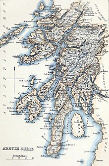
Argyll (/ɑːrˈɡaɪl/; archaically Argyle; Scottish Gaelic: Earra-Ghàidheal, pronounced [ˈaːrˠəɣɛːəl̪ˠ]), sometimes called Argyllshire, is a historic county and registration county of western Scotland.
Argyll is of ancient origin, and broadly corresponds to the ancient kingdom of Dál Riata less the parts which were in Ireland. Argyll was also a medieval bishopric with its cathedral at Lismore, as well as an early modern earldom, elevated to become a dukedom in 1701 with the creation of the Duke of Argyll.
Argyll borders Inverness-shire to the north, Perthshire and Dunbartonshire to the east, and—separated by the Firth of Clyde—neighbours Renfrewshire and Ayrshire to the south-east, and Buteshire to the south.
Between 1890 and 1975, Argyll was an administrative county with a county council. The county town was historically Inveraray, but from its creation in 1890 the county council was based at Lochgilphead. Most of the historic county's territory is within the modern council area of Argyll and Bute, with the main differences being that the Morvern and Ardnamurchan areas from the historic county are now in the Highland council area, whilst the Isle of Bute and the Helensburgh area were not in historic Argyll but are now in the Argyll and Bute council area.
There was an Argyllshire constituency of the Parliament of Great Britain then Parliament of the United Kingdom from 1708 until 1983.
© MMXXIII Rich X Search. We shall prevail. All rights reserved. Rich X Search