Back إدارة أتاكورا Arabic Atakora AST Ataqora departamenti Azerbaijani Атакара (дэпартамент) Byelorussian Атакара (дэпартамэнт) BE-X-OLD Атакора (департамент) Bulgarian Atakora Breton Atakora Catalan Atakora Department CEB Atakora Danish
Atakora | |
|---|---|
 | |
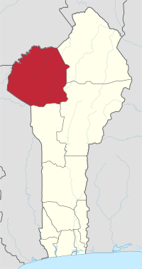
 Map highlighting the Atakora Department | |
| Coordinates: 10°18′N 1°23′E / 10.300°N 1.383°E | |
| Country | |
| Capital | Natitingou |
| Area | |
| • Total | 20,499 km2 (7,915 sq mi) |
| Population (2013 census) | |
| • Total | 769,337 |
| • Density | 38/km2 (97/sq mi) |
| Time zone | UTC+1 (WAT) |
Atakora [a.ta.kɔ.ʁa] (also spelled Atacora, named for the Atakora Mountains) is the northwesternmost department of Benin. Externally it borders Togo to the west and Burkina Faso to the north; internally it borders the departments of Alibori, Borgou and Donga. Major towns in the Atakora include Natitingou and Tanguiéta, and the major tourist areas include the Tata Somba houses, Pendjari National Park, and various waterfalls. The department of Atakora was bifurcated in 1999, with its southern territory removed to form the newly created Donga Department. The capital of Atakora Department is Natitingou, which lies among the Atakora Mountains.
As of 2013[update], the total population of the department was 772,262, with 380,448 males and 391,814 females. The proportion of women was 50.70%. The total rural population was 62.80%, while the urban population was 37.20%. The total labour force in the department was 170,333, of which 27.20% were women. The proportion of households with no level of education was 72.80%.
- ^ "Benin". Geohive. Archived from the original on 2017-02-01. Retrieved 25 November 2016.
© MMXXIII Rich X Search. We shall prevail. All rights reserved. Rich X Search