Back Baganuur BCL Baganuur CEB Baganuur German Baganuur Spanish باگانور Persian Baganuur French बगन्नूर Hindi Baganuur Italian Baganūras Lithuanian Баганур Macedonian
Baganuur District
Багануур дүүрэг ᠪᠠᠭᠠᠨᠠᠭᠤᠷᠲᠡᠭᠦᠷᠭᠡ | |
|---|---|
 A sign on a road leading to Baganuur | |
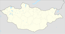
| Coordinates: 47°47′02″N 108°22′20″E / 47.78389°N 108.37222°E | |
| Country | Mongolia |
| Municipality | Ulaanbaatar |
| Raion of Ulaanbaatar | 1980 |
| Reorganized as district | 1992 |
| Government | |
| • Body | Citizens' Representatives Khural of the Baganuur district |
| • Governor of District | S.Davaasüren |
| Area | |
| • Total | 620.2 km2 (239.5 sq mi) |
| Elevation | 1,349 m (4,426 ft) |
| Population (2024) | |
| • Total | 28,926 |
| Time zone | UTC+8 (UTC + 8) |
| Area code | +976 (0) 21 |
| Website | http://bnd.ub.gov.mn/ |

Baganuur (Mongolian: Багануур, ᠪᠠᠭᠠᠨᠠᠭᠤᠷ, Little Lake) is one of nine düüregs (districts) of the Mongolian capital of Ulaanbaatar. It is subdivided into six khoroos (subdistricts).
Baganuur is a distanced district, located as an exclave of 620 square kilometres (239 sq mi) on the border between the Töv and Khentii aimags. It was created as a Soviet army base for the 12th Motor Rifle Division. Later the largest open-pit coal mine in Mongolia was built here. Baganuur city is one of the largest industrial production locations in Mongolia, especially coal mining and would rank among the country's ten largest cities. There are efforts under way to separate its administration from the capital to make it an independent city.
© MMXXIII Rich X Search. We shall prevail. All rights reserved. Rich X Search


