Back بسكنتا Arabic بسكنتا ARZ Μπασκίντα Greek Baskinta Spanish بسکنتا Persian Baskinta French Baskinta Italian Baskinta NN Baskinta PAM Баскинта Russian
This article needs additional citations for verification. (November 2020) |
Baskinta
بسكنتا | |
|---|---|
Town | |
 Baskinta | |
| Coordinates: 33°57′N 35°47′E / 33.950°N 35.783°E | |
| Country | |
| Governorate | Mount Lebanon Governorate |
| District | Matn District |
| Elevation | 1,300 m (4,300 ft) |
| Highest elevation | 1,800 m (5,900 ft) |
| Lowest elevation | 1,200 m (3,900 ft) |
| Time zone | UTC+2 (EET) |
| • Summer (DST) | UTC+3 (EEST) |
| Dialing code | +961 |
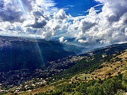
Baskinta (Arabic: بسكنتا) is a Lebanese village situated at an altitude ranging from 1250 metres above sea level and climbs up to approximately 1800 meters of height at Qanat Bakish, making it one of the highest villages of Lebanon. It is located 43 kilometers north east of Beirut.
Baskinta is known for its natural environment and moderate climate.[citation needed] Baskinta is becoming a cycling spot for mountain biking amateurs with some off-road trails and a developed cycling community.[citation needed] It was also the capital city of the Syriac Christian state of Marada. Baskinta is also known for the variety of its fruit especially apples and vineyards. The residents are Christians: 70% Maronites and 30% Greek Orthodox. There are 15,000 residents in Baskinta and 3 schools: the Saint Pierre College Brothers, the Official High School of Baskinta and the Saint Vincent School.
© MMXXIII Rich X Search. We shall prevail. All rights reserved. Rich X Search
