Back باتل، دوغو ساسکس AZB Батъл Bulgarian Battle Catalan Battle (lungsod) CEB Battle, Dwyrain Sussex Welsh Battle (East Sussex) German Battle (East Sussex) Spanish باتل، ساسکس شرقی Persian Battle Finnish Battle (Angleterre) French
| Battle | |
|---|---|
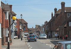
 View along the High Street towards the abbey | |
Location within East Sussex | |
| Area | 31.8 km2 (12.3 sq mi) [1] |
| Population | 6,800 (2021)[2] |
| • Density | 503/sq mi (194/km2) |
| OS grid reference | TQ747160 |
| • London | 48 miles (77 km) NNW |
| District | |
| Shire county | |
| Region | |
| Country | England |
| Sovereign state | United Kingdom |
| Post town | BATTLE |
| Postcode district | TN33 |
| Dialling code | 01424 |
| Police | Sussex |
| Fire | East Sussex |
| Ambulance | South East Coast |
| UK Parliament | |
| Website | Town Council |
Battle is a town and civil parish in the district of Rother in East Sussex, England. It lies 50 miles (80 km) south-east of London, 27 miles (43 km) east of Brighton and 20 miles (32 km) east of Lewes. Hastings is to the south-east and Bexhill-on-Sea to the south. Battle is in the designated High Weald Area of Outstanding Natural Beauty. The parish population was 6,673 according to the 2011 Census[2] and 6,800 in the 2021 census.[3] Battle contains the site of, and is named after, the Battle of Hastings, where William, Duke of Normandy, defeated King Harold II to become William I of England in 1066. For some 250 years after 1066, official documents referred to the town as (Latin) Bellum or (French) Bataille.
- ^ "East Sussex in Figures". East Sussex County Council. Archived from the original on 28 December 2012. Retrieved 26 April 2008.
- ^ a b "Town population 2011". Neighbourhood Statistics. Office for National Statistics. Archived from the original on 4 March 2016. Retrieved 6 October 2015.
- ^ ONS (2024). "2021 census".
© MMXXIII Rich X Search. We shall prevail. All rights reserved. Rich X Search
