Back باي هاربور آيلاند Arabic باى هاربور آيلاند ARZ Bay Harbor Islands Catalan Бей-Гарбор-Айлендс (Флорида) CE Bay Harbor Islands CEB Bay Harbor Islands, Florida Welsh Bay Harbor Islands German Bay Harbor Islands Spanish Bay Harbor Islands (Florida) Basque بی هاربر آیلندز، فلوریدا Persian
Bay Harbor Islands, Florida | |
|---|---|
| Town of Bay Harbor Islands | |
 Location in Miami-Dade County, Florida | |
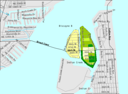
 U.S. Census Bureau map showing the Town's boundaries | |
| Coordinates: 25°53′15″N 80°8′9″W / 25.88750°N 80.13583°W | |
| Country | |
| State | |
| County | |
| Incorporated | April 28, 1947 |
| Government | |
| • Type | Council-Manager |
| • Mayor | Joshua D. Fuller |
| • Vice Mayor | Isaac Salver |
| • Council Members | Stephanie Bruder, Molly Diallo, Teri D'Amico, Eric Rappaport, and Robert H. Yaffe |
| • Interim Town Manager | Jenice Rosado |
| • Town Clerk | Yvonne P. Hamilton |
| Area | |
| • Total | 0.42 sq mi (1.09 km2) |
| • Land | 0.40 sq mi (1.03 km2) |
| • Water | 0.03 sq mi (0.06 km2) |
| Elevation | 7 ft (2 m) |
| Population | |
| • Total | 5,922 |
| • Density | 14,954.55/sq mi (5,768.58/km2) |
| Time zone | UTC-5 (Eastern (EST)) |
| • Summer (DST) | UTC-4 (EDT) |
| ZIP code | 33154 |
| Area code(s) | 305, 786, 645 |
| FIPS code | 12-03975[3] |
| GNIS feature ID | 0278201[4] |
| Website | www |
Bay Harbor Islands is a town in Miami-Dade County, Florida, United States. The city is part of the Miami metropolitan area of South Florida. It is separated from the mainland by Biscayne Bay. The population was 5,922 at the 2020 US census.[2]
- ^ "2022 U.S. Gazetteer Files: Florida". United States Census Bureau. Retrieved December 28, 2022.
- ^ a b "P1. Race – Bay Harbor Islands town, Florida: 2020 DEC Redistricting Data (PL 94-171)". U.S. Census Bureau. Retrieved December 28, 2022.
- ^ "U.S. Census website". United States Census Bureau. Retrieved January 31, 2008.
- ^ "US Board on Geographic Names". United States Geological Survey. October 25, 2007. Retrieved January 31, 2008.
© MMXXIII Rich X Search. We shall prevail. All rights reserved. Rich X Search