Bayt Umm al-Mays
بيت أم الميس | |
|---|---|
| Etymology: The house of the meis-tree (Cordia myxa)[1] | |
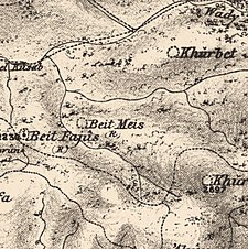
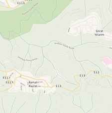
A series of historical maps of the area around Bayt Umm al-Mays (click the buttons) | |
Location within Mandatory Palestine | |
| Coordinates: 31°46′49″N 35°04′49″E / 31.78028°N 35.08028°E | |
| Palestine grid | 157/131 |
| Geopolitical entity | Mandatory Palestine |
| Subdistrict | Jerusalem |
| Date of depopulation | October 21, 1948[4] |
| Area | |
| • Total | 1,013 dunams (1.013 km2 or 250 acres) |
| Population (1945) | |
| • Total | 70[2][3] |
| Cause(s) of depopulation | Military assault by Yishuv forces |
Bayt Umm al-Mays was a small Palestinian Arab village in the Jerusalem Subdistrict.
The village was established and settled during the late British Mandatory period, and had 70 inhabitants in 1945.[5] It was depopulated during the 1948 Arab-Israeli War on October 21, 1948, by the Har'el Brigade of Operation ha-Har. It was located 14 km west of Jerusalem.
- ^ Palmer, 1881, p. 286
- ^ Department of Statistics, 1945, p. 24
- ^ Government of Palestine, Department of Statistics. Village Statistics, April, 1945. Quoted in Hadawi, 1970, p. 56
- ^ Morris, 2004, p. xx, village #344. Also gives cause of depopulation, both with a "?"
- ^ Grossman, D. (1986). "Oscillations in the Rural Settlement of Samaria and Judaea in the Ottoman Period". in Shomron studies. Dar, S., Safrai, S., (eds). Tel Aviv: Hakibbutz Hameuchad Publishing House. p. 362
© MMXXIII Rich X Search. We shall prevail. All rights reserved. Rich X Search


