Back بيت ساحور Arabic بيت ساحور ARZ Beit Sahour Catalan Bayt Sāḩūr CEB Bait Sahur German Χωρίον των Ποιμένων Greek Beit Sahour Spanish Beit Sahour Basque بیت ساحور Persian Beit Sahur Finnish
Beit Sahour | |
|---|---|
| Arabic transcription(s) | |
| • Arabic | بيت ساحور |
| • Latin | Bayt Sāḥūr |
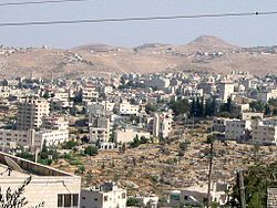
 Beit Sahour with the Herodium in the background | |
| Coordinates: 31°42′1″N 35°13′30″E / 31.70028°N 35.22500°E | |
| State | State of Palestine |
| Governorate | Bethlehem |
| Government | |
| • Type | Municipality |
| • Head of Municipality | Hani Hayek [1] |
| Area | |
| • Municipality type B | 6,945 dunams (6.9 km2 or 2.7 sq mi) |
| Population (2017)[2] | |
| • Municipality type B | 13,281 |
| • Density | 1,900/km2 (5,000/sq mi) |
| • Metro | 97,559 (Bethlehem area) |
| Name meaning | "House of vigilance",[3] "house of the night watch",[4] or "house of the magicians"[5] |
| Website | Beit Sahour Municipality |
Beit Sahour or Beit Sahur (Arabic: بيت ساحور, romanized: ; Palestine grid 170/123) is a Palestinian town east of Bethlehem, in the Bethlehem Governorate of the State of Palestine. The city is under the administration of the Palestinian National Authority. The population was of 13,281 in 2017,[6] consisting of approximately 80% Christians (most of them Greek Orthodox) and 20% Muslims.[7]
Christian tradition holds Beit Sahour to be the site of the Annunciation to the Shepherds.[8] There are two enclosures in the eastern part of Beit Sahour that are claimed by different Christian denominations to be the actual 'Shepherds Field': one belonging to the Greek Orthodox Church, and the other, the Catholic site, belonging to the Franciscan Custody of the Holy Land.
The mainly Christian Palestinian inhabitants are being pressured by encroaching Israeli settlements, with one housing development threatened with demolition.[8]
- ^ [1] Archived November 20, 2008, at the Wayback Machine
- ^ "Main Indicators by Type of Locality - Population, Housing and Establishments Census 2017" (PDF). Palestinian Central Bureau of Statistics (PCBS). Retrieved 2021-01-19.
- ^ Cite error: The named reference
ARIJprofwas invoked but never defined (see the help page). - ^ Cite error: The named reference
VP16was invoked but never defined (see the help page). - ^ Palmer (1881), p. 286
- ^ 2017 PCBS Census Palestinian Central Bureau of Statistics.
- ^ History, Economy, and Tourism Archived 2014-03-20 at the Wayback Machine Beit Sahour Municipality.
- ^ a b Philp, Catherine (24 December 2013). "Settlements choke peace in the little town of Bethlehem". The Times. pp. 28–29.(subscription required) Accessed 5 May 2022 via pressreader.com here and here.
© MMXXIII Rich X Search. We shall prevail. All rights reserved. Rich X Search


