Back مقاطعة بلمونت (أوهايو) Arabic بلمونت بؤلگهسی، اوهایو AZB Belmont County, Ohio BAR Белмонт (окръг, Охайо) Bulgarian বেলমন্ট কাউন্টি, ওহাইও BPY Belmont Gông (Ohio) CDO Belmont County CEB Belmont County, Ohio Welsh Belmont County (Ohio) Danish Belmont County German
Belmont County | |
|---|---|
 | |
| Motto(s): | |
 Location within the U.S. state of Ohio | |
 Ohio's location within the U.S. | |
| Coordinates: 40°01′N 80°59′W / 40.02°N 80.99°W | |
| Country | |
| State | |
| Founded | September 7, 1801 (created) November 7, 1801 (organized) |
| Named for | "beautiful mountain" in French |
| Seat | St. Clairsville |
| Largest city | Martins Ferry |
| Area | |
| • Total | 541.27 sq mi (1,401.9 km2) |
| • Land | 532.13 sq mi (1,378.2 km2) |
| • Water | 9.14 sq mi (23.7 km2) 1.7% |
| Population (2020) | |
| • Total | 66,497 |
| • Density | 120/sq mi (50/km2) |
| Time zone | UTC−5 (Eastern) |
| • Summer (DST) | UTC−4 (EDT) |
| Congressional district | 6th |
| Website | www |
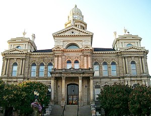
Belmont County is a county in the U.S. state of Ohio. As of the 2020 United States census, the population was 66,497.[2] Its county seat is St. Clairsville, while its largest city is Martins Ferry. The county was created on September 7, 1801, and organized on November 7, 1801.[3] It takes its name from the French for "beautiful mountain".[4]
Belmont County is part of the Wheeling metropolitan area.
- ^ "Belmont County Flag". Capitol Square Review and Advisory Board. Retrieved January 26, 2015.
- ^ "2020 Population and Housing State Data". Census.gov. Retrieved July 23, 2022.
- ^ McKelvey, A. T.. Centennial history of Belmont County, Ohio, and representative citizens. pp. 46–47. Chicago, Biographical Pub. Co. (1903).
- ^ "Belmont County data". Ohio State University Extension Data Center. Retrieved April 28, 2007.[dead link]
© MMXXIII Rich X Search. We shall prevail. All rights reserved. Rich X Search

