Back مقاطعة بينينغتون (فيرمونت) Arabic Condáu de Bennington AST Bennington County, Vermont BAR Бенингтън (окръг, Вермонт) Bulgarian বেনিংটন কাউন্টি, ভার্মন্ট BPY Bennington Gông (Vermont) CDO Беннингтон (гуо, Вермонт) CE Bennington County CEB Bennington County, Vermont Welsh Bennington County German
Bennington County | |
|---|---|
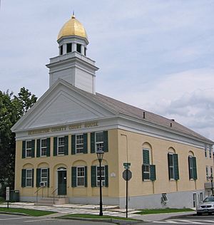
 Bennington County courthouse in Manchester | |
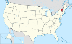
 Location within the U.S. state of Vermont | |
 Vermont's location within the U.S. | |
| Coordinates: 43°01′46″N 73°06′29″W / 43.029419°N 73.107956°W | |
| Country | |
| State | |
| Founded | 1778 |
| Named for | Benning Wentworth |
| Shire Town | Bennington & Manchester |
| Largest town | Bennington |
| Area | |
| • Total | 678 sq mi (1,760 km2) |
| • Land | 675 sq mi (1,750 km2) |
| • Water | 2.7 sq mi (7 km2) 0.4% |
| Population (2020) | |
| • Total | 37,347 |
| • Density | 55/sq mi (21/km2) |
| Time zone | UTC−5 (Eastern) |
| • Summer (DST) | UTC−4 (EDT) |
| Congressional district | At-large |
| Website | www |
Bennington County is a county in the U.S. state of Vermont. As of the 2020 census, the population was 37,347.[1] The shire towns (county seats) are jointly Bennington ("The Southshire") and Manchester ("The Northshire"),[2] and the largest municipality is Bennington. The county was created in 1778.[3]
- ^ "State & County QuickFacts". United States Census Bureau. Retrieved October 28, 2021.
- ^ "Find a County". National Association of Counties. Archived from the original on May 31, 2011. Retrieved June 7, 2011.
- ^ "Vermont: Individual County Chronologies". Vermont Atlas of Historical County Boundaries. The Newberry Library. 2008. Archived from the original on May 10, 2015. Retrieved June 30, 2015.
© MMXXIII Rich X Search. We shall prevail. All rights reserved. Rich X Search