Back بيكسلي Arabic بيكسلى (فرانكلن, اوهايو) ARZ بکسلی، اوهایو AZB Бексли (Огайо) CE Bexley, Ohio Welsh Bexley (Ohio) Spanish Bexley (Ohio) Basque بکسلی، اوهایو Persian Bexley (Ohio) French Bexley, Ohio HT
Bexley, Ohio | |
|---|---|
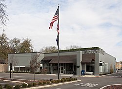
 Bexley City Hall | |
 Interactive map of the city | |
| Coordinates: 39°57′54″N 82°56′03″W / 39.96500°N 82.93417°W | |
| Country | United States |
| State | Ohio |
| County | Franklin |
| Government | |
| • Type | Mayor–Council |
| Area | |
| • Total | 2.44 sq mi (6.32 km2) |
| • Land | 2.42 sq mi (6.27 km2) |
| • Water | 0.02 sq mi (0.05 km2) |
| Elevation | 791 ft (241 m) |
| Population (2020) | |
| • Total | 13,928 |
| • Estimate (2023)[3] | 12,785 |
| • Density | 5,752.99/sq mi (12,785/km2) |
| Time zone | UTC-5 (EST) |
| • Summer (DST) | UTC-4 (EDT) |
| ZIP code | 43209 |
| Area code | 614 and 380 |
| FIPS code | 39-06278 |
| GNIS ID | 1086097[2] |
| Website | bexley.org |
Bexley is a city in Franklin County, Ohio, United States. The population was 13,928 at the 2020 census. The city is a suburb and geographic enclave of Columbus, situated on the banks of Alum Creek next to Driving Park and Wolfe Park, just east of the Franklin Park Conservatory. It is horizontally bisected by the National Road (Main Street), serving as a reminder of Bexley's origins as a merger between the Bullitt Park neighborhood to the north, and the community of Pleasant Ridge to the south.
The suburb is home to large houses and estates, located primarily in Bullitt Park. The most famous of these include the Jeffrey Park Mansion (a.k.a. "Kelveden"), the home of the president of Ohio State University, and the Ohio Governor's Mansion, the official residence of Ohio governors since 1957.
- ^ "ArcGIS REST Services Directory". United States Census Bureau. Retrieved September 20, 2022.
- ^ a b U.S. Geological Survey Geographic Names Information System: Bexley, Ohio
- ^ "Annual Estimates of the Resident Population for Incorporated Places in Ohio: April 1, 2020 to July 1, 2023". United States Census Bureau. Retrieved June 3, 2024.
© MMXXIII Rich X Search. We shall prevail. All rights reserved. Rich X Search

