Back حديقة بيسكين الوطنية Arabic Biskeyn milli parkı Azerbaijani Taman Nasional Biscayne BAN Бискейн (национален парк) Bulgarian Parc Nacional de Biscayne Catalan Biscayne National Park CEB Národní park Biscayne Czech Biscayne National Park Danish Biscayne-Nationalpark German Parque nacional Biscayne Spanish
| Biscayne National Park | |
|---|---|
IUCN category V (protected landscape/seascape) | |
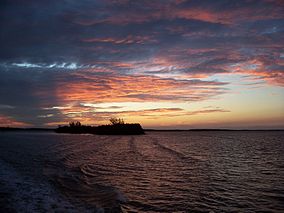
 Sunset at Biscayne National Park in December 2005 | |
Location in Florida | |
| Location | Miami-Dade County, Florida, U.S. |
| Nearest city | Homestead |
| Coordinates | 25°28′10″N 80°11′10″W / 25.46944°N 80.18611°W |
| Area | 172,971 acres (699.99 km2)[1] |
| Established | June 28, 1980 |
| Visitors | 701,023 (in 2022)[2] |
| Governing body | National Park Service |
| Website | Biscayne National Park |
Biscayne National Park is an American national park located south of Miami, Florida in Miami-Dade County. The park preserves Biscayne Bay and its offshore barrier reefs. Ninety-five percent of the park is water, and the shore of the bay is the location of an extensive mangrove forest. The park covers 172,971 acres (270.3 sq mi; 700.0 km2) and includes Elliott Key, the park's largest island and northernmost of the true Florida Keys, formed from fossilized coral reef. The islands farther north in the park are transitional islands of coral and sand. The offshore portion of the park includes the northernmost region of the Florida Reef, one of the largest coral reefs in the world.
Biscayne National Park protects four distinct ecosystems: the shoreline mangrove swamp, the shallow waters of Biscayne Bay, the coral limestone keys and the offshore Florida Reef. The shoreline swamps of the mainland and island margins provide a nursery for larval and juvenile fish, molluscs and crustaceans. The bay waters harbor immature and adult fish, seagrass beds, sponges, soft corals, and manatees. The keys are covered with tropical vegetation including endangered cacti and palms, and their beaches provide nesting grounds for endangered sea turtles. Offshore reefs and waters harbor more than 200 species of fish, pelagic birds, whales and hard corals. Sixteen endangered species including Schaus' swallowtail butterflies, smalltooth sawfish, manatees, and green and hawksbill sea turtles may be observed in the park. Biscayne also has a small population of threatened American crocodiles and a few American alligators.
The people of the Glades culture inhabited the Biscayne Bay region as early as 10,000 years ago before rising sea levels filled the bay. The Tequesta people occupied the islands and shoreline from about 4,000 years before the present to the 16th century, when the Spanish took possession of Florida. Reefs claimed ships from Spanish times through the 20th century, with more than 40 documented wrecks within the park's boundaries. While the park's islands were farmed during the 19th and early 20th centuries, their rocky soil and periodic hurricanes made agriculture difficult to sustain.
In the early 20th century the islands became secluded destinations for wealthy Miamians who built getaway homes and social clubs. Mark C. Honeywell's guesthouse on Boca Chita Key that featured a mock lighthouse was the area's most elaborate private retreat. The Cocolobo Cay Club was at various times owned by Miami developer Carl G. Fisher, yachtsman Garfield Wood, and President Richard Nixon's friend Bebe Rebozo, and was visited by four United States presidents. The amphibious community of Stiltsville, established in the 1930s in the shoals of northern Biscayne Bay, took advantage of its remoteness from land to offer offshore gambling and alcohol during Prohibition. After the Cuban Revolution of 1959, the Central Intelligence Agency and Cuban exile groups used Elliott Key as a training ground for infiltrators into Fidel Castro's Cuba.
Originally proposed for inclusion in Everglades National Park, Biscayne Bay was removed from the proposed park to ensure Everglades' establishment. The area remained undeveloped until the 1960s, when a series of proposals were made to develop the keys in the manner of Miami Beach, and to construct a deepwater seaport for bulk cargo, along with refinery and petrochemical facilities on the mainland shore of Biscayne Bay. Through the 1960s and 1970s, two fossil-fueled power plants and two nuclear power plants were built on the bay shores. A backlash against development led to the 1968 designation of Biscayne National Monument. The preserved area was expanded by its 1980 re-designation as Biscayne National Park. The park is heavily used by boaters, and apart from the park's visitor center on the mainland and a jetty at Black Point Marina, its land and sea areas are accessible only by boat.
- ^ "Listing of acreage – December 31, 2011" (XLSX). Land Resource Division, National Park Service. Retrieved 5 March 2012. (National Park Service Acreage Reports)
- ^ "NPS Annual Recreation Visits Report". National Park Service. Retrieved October 16, 2023.
© MMXXIII Rich X Search. We shall prevail. All rights reserved. Rich X Search

