Back Bondoukou (kapital sa distrito) CEB Bondoukou Danish Bondoukou German Bondoukou Spanish Bondoukou French Bondoukou FRR בונדוקו HE Bondoukou Croatian Bondoukou IG Bondoukou Italian
Bondoukou
Bonduku; Bontuku | |
|---|---|
City, sub-prefecture, and commune | |
 Bondoukou in 1910 | |
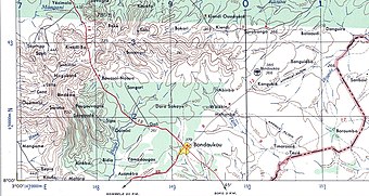
 Region around Bondoukou town, showing international border in red, c. 1957. | |
| Coordinates: 8°2′N 2°48′W / 8.033°N 2.800°W[1] | |
| Country | |
| District | Zanzan |
| Region | Gontougo |
| Department | Bondoukou |
| Government | |
| • Mayor | Kone Hiliassou |
| Area | |
| • Total | 725 km2 (280 sq mi) |
| Elevation | 343 m (1,125 ft) |
| Population (2021 census)[3] | |
| • Total | 141,568 |
| • Density | 200/km2 (510/sq mi) |
| • City | 88,783[2] |
| (2014 census) | |
| Time zone | UTC+0 (GMT) |
Bondoukou (var. Bonduku, Bontuku) is a city in northeastern Ivory Coast, 420 km northeast of Abidjan.[4] It is the seat of both Zanzan District and Gontougo Region. It is also a commune and the seat of and a sub-prefecture of Bondoukou Department.
Bondoukou is situated near the border with Ghana, just across the border from the Ghanaian town of Sampa. The city lies at the junction of the main A1 highway, with roads to Sorobango to the north and Ghana to the east.
- ^ "Ivory Coast Cities Longitude & Latitude". sphereinfo.com. Archived from the original on 13 September 2012. Retrieved 18 November 2010.
- ^ Citypopulation.de Population of cities & localities in Ivory Coast
- ^ Citypopulation.de Population of the regions and sub-prefectures of Ivory Coast
- ^ Conflit foncier dans le nord ivoirien : 8 morts et 21 blessés. Places Bondoukou 424 km NE of capitol. APA : 8/9/2008
© MMXXIII Rich X Search. We shall prevail. All rights reserved. Rich X Search
