Back Frontière entre la Chine continentale et Hong Kong French 香港の境界 Japanese 香港深圳边界 Chinese 香港邊界 ZH-YUE

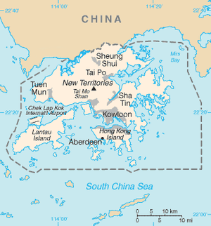
The Boundaries of Hong Kong, officially the Boundary of the Administrative Division of the Hong Kong Special Administrative Region of the People's Republic of China[1][2] (simplified Chinese: 中华人民共和国香港特别行政区行政区域界线; traditional Chinese: 中華人民共和國香港特別行政區行政區域界綫), is a regulated administrative border with border control in force under the One country, two systems constitutional principle, which separates the Hong Kong Special Administrative Region from mainland China, by land border fence of 30 km (19 mi) and maritime boundary of 733 km (455 mi),[1] enforcing a separate immigration and customs-controlled jurisdiction from mainland China.
The boundaries of Hong Kong are patrolled and controlled by the Hong Kong Police Force and its Marine Region and the Immigration Department at land and sea. The land boundary also includes a buffer zone, known as Frontier Closed Area.

- ^ a b basiclaw.gov.hk - Description of the Boundary of the Administrative Division of the Hong Kong Special Administrative Region of the People’s Republic of China
- ^ elegislation.gov.hk - 中華人民共和國香港特別行政區行政區域界綫文字表述 Description of the Boundary of the Administrative Division of the Hong Kong Special Administrative Region of the People’s Republic of China
© MMXXIII Rich X Search. We shall prevail. All rights reserved. Rich X Search