Back جزر بريوني Arabic Бриони Bashkir Бриони Bulgarian Brijuni BS Brijuni Czech Brijuni Danish Brijuni German Brijuna insularo Esperanto Islas Brioni Spanish Brijuni uharteen Parke Nazionala Basque
This article needs additional citations for verification. (December 2010) |
| Brijuni Islands National Park | |
|---|---|
| Native name Croatian: Nacionalni park Brijuni | |
Brijuni | |
| Location | Istria County, Croatia |
| Coordinates | 44°55′N 13°46′E / 44.917°N 13.767°E |
| Area | 7.5 km2 (2.9 sq mi) |
| Official name | Nacionalni park Brijuni |
| Archipelago | Brijuni Islands |
| Total islands | 14 |
| Major islands | Veli Brijun, Mali Brijun |
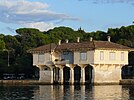
The Brijuni (pronounced [brijǔːni]) or the Brijuni Islands (also known as the Brionian Islands; Italian: Isole Brioni) are a group of fourteen small islands in the Croatian part of the northern Adriatic Sea, separated from the west coast of the Istrian peninsula by the narrow Fažana Strait (a.k.a. Fasana Channel). The largest island, Veliki Brijun Island (also known as Italian: Brioni Grande or Croatian: Veli Brijun), (5.6 km2), lies 2 kilometres (1 mile) off the coast. The second largest island is Mali Brijun with an area of 1.07 km2, and twelve much smaller islands. Known for their scenery, the islands are a holiday resort and a Croatian National Park.
The islands gained worldwide fame in 1956 during the Brioni Meeting when the main leaders of the Non-Aligned Movement met with the host, Yugoslav president Tito, to form the Brioni Declaration which served as the foundation for the policies the movement would follow.[1] Another event which took place on the islands was the 1991 Brioni Agreement.
© MMXXIII Rich X Search. We shall prevail. All rights reserved. Rich X Search


