Back بشري (لبنان) Arabic بشرى (بلده فى قضاء بشرى) ARZ Бшарре Bulgarian Bsharra Catalan Bcharré CEB Bšarré Czech Bischarri German Μπσαρί Greek Bisharri Spanish بشری (لبنان) Persian
This article needs additional citations for verification. (July 2020) |
Bsharri
بشرّي | |
|---|---|
City | |
 Bsharri | |
| Coordinates: 34°15′4″N 36°0′40″E / 34.25111°N 36.01111°E | |
| Country | |
| Governorate | North Governorate |
| District | Bsharri District |
| Area | |
| • Total | 62.07 km2 (23.97 sq mi) |
| Elevation | 1,500 m (4,900 ft) |
| Population | |
| • Total | 24,000 |
| • Density | 390/km2 (1,000/sq mi) |
| Demonym | Bsherroniye |
| Time zone | UTC+2 (EET) |
| • Summer (DST) | UTC+3 (EEST) |
| Dialing code | +961 |
| Website | www.bcharri.gov.lb |
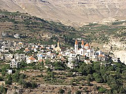
Bsharri (Arabic: بشرّي Bšarrī; also romanized Becharre, Bcharre, Bsharre, Bcharre Al Arz) is a town at altitudes between 1,100 m (3,600 ft) and 3,088 m (10,131 ft).[1] It is located in the Bsharri District of the North Governorate in Lebanon. Bsharri is the site of the only remaining original “Cedars of God” (Cedrus libani), and is the birthplace of the famous poet, painter and sculptor Khalil Gibran. A museum in the town honours his life and work.
Bsharri is also home to Lebanon's oldest skiing area, the Cedars Ski Resort, and to the country's first ski lift, built in 1953. The resort is about a two-hour drive and 130 km (81 mi) from Beirut. Qurnat as Sawdā Mountain in Bsharri is the highest peak in the Levant, at 3,088 meters above sea level.[2]
It is at the head of the Holy Kadisha Valley, which shelters some of the oldest Christian monastic communities in the Middle East.[3] Bsharri, a center of Maronite Christianity, also has the biggest cathedral in the region, the Saint Saba Cathedral, built by Anthony II Peter Arida. Bsharri is sometimes called “the city of churches” as it is home to some 37 churches. The Kadisha Valley and Cedars of God are a UNESCO World Heritage Site.[4]
- ^ Google (1 August 2023). "Bsharri" (Map). Google Maps. Google. Retrieved 1 August 2023.
- ^ "Qurnat as Sawda' Weather Forecast (3088m)". www.mountain-forecast.com. Retrieved 2023-08-02.
- ^ https://www.livius.org/articles/place/bsharre/
- ^ "Ouadi Qadisha (the Holy Valley) and the Forest of the Cedars of God (Horsh Arz el-Rab)". UNESCO. Retrieved 16 March 2020.
© MMXXIII Rich X Search. We shall prevail. All rights reserved. Rich X Search
