Back مقاطعة بوجانان (ميزوري) Arabic Buchanan County, Missouri BAR Бюканън (окръг, Мисури) Bulgarian বুচানন কাউন্টি, মিসৌরি BPY Buchanan Gông (Missouri) CDO Бьюкенен (гуо, Миссури) CE Buchanan County (kondado sa Tinipong Bansa, Missouri) CEB Buchanan County, Missouri Welsh Buchanan County (Missouri) Danish Buchanan County (Missouri) German
Buchanan County | |
|---|---|
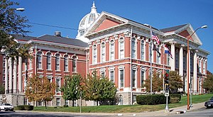
 The Buchanan County Courthouse in downtown St. Joseph | |
 Location within the U.S. state of Missouri | |
 Missouri's location within the U.S. | |
| Coordinates: 39°40′N 94°49′W / 39.67°N 94.81°W | |
| Country | |
| State | |
| Founded | December 31, 1838 |
| Named for | James Buchanan |
| Seat | St. Joseph |
| Largest city | St. Joseph |
| Area | |
| • Total | 415 sq mi (1,070 km2) |
| • Land | 408 sq mi (1,060 km2) |
| • Water | 6.6 sq mi (17 km2) 1.6% |
| Population (2020) | |
| • Total | 84,793 |
| • Density | 200/sq mi (79/km2) |
| Time zone | UTC−6 (Central) |
| • Summer (DST) | UTC−5 (CDT) |
| Congressional district | 6th |
| Website | www |
Buchanan County is located in the U.S. state of Missouri. As of the 2020 United States Census, the population was 84,793.[1] Its county seat is St. Joseph.[2] When originally formed in 1838, the county was named Roberts County, after settler Hiram Roberts. It was renamed in 1839 for James Buchanan, then a U.S. Senator and later President of the United States. The county was formed from land annexed to Missouri, as were five other counties.
Buchanan County is included in the Kansas City CSA.
- ^ "2020 Population and Housing State Data". United States Census Bureau. Retrieved August 31, 2021.
- ^ "Find a County". National Association of Counties. Archived from the original on May 31, 2011. Retrieved June 7, 2011.
© MMXXIII Rich X Search. We shall prevail. All rights reserved. Rich X Search