Back Bundeena CEB باندینا، نیوساوت ولز Persian Bundeena Polish Bundeena, New South Wales Romanian Bundeena Swedish
| Bundeena Sydney, New South Wales | |||||||||||||||
|---|---|---|---|---|---|---|---|---|---|---|---|---|---|---|---|
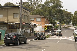
 Town centre, November 2009 | |||||||||||||||
 | |||||||||||||||
| Coordinates | 34°5′17.02″S 151°9′14.62″E / 34.0880611°S 151.1540611°E | ||||||||||||||
| Population | 2,103 (2021 census)[1] | ||||||||||||||
| • Density | 1,107/km2 (2,870/sq mi) | ||||||||||||||
| Postcode(s) | 2230[2] | ||||||||||||||
| Elevation | 16 m (52 ft) | ||||||||||||||
| Area | 1.9 km2 (0.7 sq mi) | ||||||||||||||
| Location | 29 km (18 mi) south of Sydney CBD | ||||||||||||||
| LGA(s) | Sutherland Shire | ||||||||||||||
| State electorate(s) | Heathcote | ||||||||||||||
| Federal division(s) | Hughes | ||||||||||||||
| |||||||||||||||
Bundeena is a village and suburb on the outskirts of southern Sydney, in the state of New South Wales, Australia. Bundeena is located 29 kilometres (18 miles) south of the Sydney central business district and is part of the local government area of the Sutherland Shire.
Bundeena is adjacent to the village of Maianbar and lies on the southern side of Port Hacking, opposite the suburbs of Cronulla and Burraneer. The village is surrounded by the Royal National Park.
The beaches at Bundeena are Jibbon Beach, Gunyah Beach, Horderns Beach and Bonnie Vale Beach. Cabbage Tree Creek and 'The Basin' separate Bundeena from the smaller village of Maianbar. A bush track and footbridge link the two villages. Bonnie Vale is also one of the few camp grounds within the Royal National Park.
- ^ Cite error: The named reference
abspopwas invoked but never defined (see the help page). - ^ Bundeena Postcode Australia Post
© MMXXIII Rich X Search. We shall prevail. All rights reserved. Rich X Search
