Back Burgh by Sands BAR Burgh by Sands Breton Burgh By Sands CEB Burgh by Sands Welsh Burgh by Sands German Burgh by Sands Spanish بورگ بای سندز Persian Burgh by Sands French Burgh by Sands Italian Burgh by Sands LLD
| Burgh by Sands | |
|---|---|
| Village and parish | |
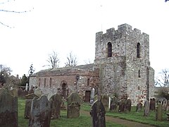
 St. Michael's Church, Burgh by Sands | |
Location in the former City of Carlisle district, Cumbria Location within Cumbria | |
| Population | 1,176 (2011) |
| OS grid reference | NY326592 |
| Civil parish |
|
| Unitary authority | |
| Ceremonial county | |
| Region | |
| Country | England |
| Sovereign state | United Kingdom |
| Post town | CARLISLE |
| Postcode district | CA5 |
| Dialling code | 01228 |
| Police | Cumbria |
| Fire | Cumbria |
| Ambulance | North West |
| UK Parliament | |
Burgh by Sands (/ˈbrʌf/ ) is a village and civil parish in the Cumberland unitary authority area of Cumbria, England, situated near the Solway Firth. The parish includes the village of Burgh by Sands along with Longburgh, Dykesfield, Boustead Hill, Moorhouse and Thurstonfield. It is notable as the site of the first recorded North African (Mauri) military unit in Roman Britain, garrisoning the frontier fort of Aballava on Hadrian's Wall in the 3rd century AD.[1] It is also where Edward I of England died in 1307.[2]
According to the 2011 census the parish had a population of 1,176.[3] The village is about seven miles (11 km) west of Carlisle city centre. The village has a primary school, a pub and a post office. It also has a statue of Edward I at some distance to the north. Burgh was on the Carlisle Navigation canal from 1823 to 1853,[4] after which it was served by the Port Carlisle railway, which was built on the bed of the canal, until its closure in 1932. From 1856 to 1964, railway trains operating on the Carlisle to Silloth line once again stopped at Burgh-by-Sands station.[5]
- ^ The Roman Inscriptions of Britain I Inscriptions on Stone, Oxford University Press 1965. p. 626. (RIB 2042)
- ^ Michael Prestwich, Edward I Yale University Press New Haven 1997 (updated edition). pp. 556–557. ISBN 0-300-07209-0
- ^ "Parish population 2011". Retrieved 23 June 2011.
- ^ David Ramshaw The Carlisle Navigation Canal P3 publications 1997 ISBN 0-9522098-5-3
- ^ "Carlisle & Silloth Bay Railway - History". Retrieved 14 April 2017.
© MMXXIII Rich X Search. We shall prevail. All rights reserved. Rich X Search

