Back صفيحة بورما Arabic Placa de Birmània Catalan Burmaplatte German Placa de Birmania Spanish صفحه برمه Persian Plaque birmane French Lempeng Burma ID Placca birmana Italian ビルマプレート Japanese 버마판 Korean
| Burma Plate | |
|---|---|
 | |
| Type | Minor |
| Approximate area | 1,100,000 km2[1] |
| Movement1 | north |
| Speed1 | 46 mm/year |
| Features | Andaman Sea |
| 1Relative to the African Plate | |

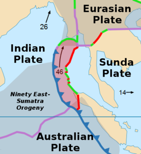
The Burma Plate is a minor tectonic plate or microplate located in Southeast Asia, sometimes considered a part of the larger Eurasian Plate. The Andaman Islands, Nicobar Islands, and northwestern Sumatra are located on the plate. This island arc separates the Andaman Sea from the main Indian Ocean to the west.
To its east lies the Sunda Plate, from which it is separated along a transform boundary, running in a rough north-south line through the Andaman Sea. This boundary between the Burma and Sunda plates is a marginal seafloor spreading centre, which has led to the opening up of the Andaman Sea (from a southerly direction) by "pushing out" the Andaman-Nicobar-Sumatra island arc from mainland Asia, a process which began in earnest approximately 4 million years ago.
To the west is the much larger India Plate, which is subducting beneath the western facet of the Burma Plate. This extensive subduction zone has formed the Sunda Trench.
- ^ "Sizes of Tectonic or Lithospheric Plates". Geology.about.com. 2014-03-05. Archived from the original on 2016-06-05. Retrieved 2016-02-02.
© MMXXIII Rich X Search. We shall prevail. All rights reserved. Rich X Search