Back مدخل بوت Arabic Bute Inlet German Bute Inlet Spanish Bute Inlet Basque Baie Bute French Бьют (бухта) Russian
| Bute Inlet | |
|---|---|
| French: Baie Bute | |
 | |
| Location | Strathcona RD, British Columbia |
| Coordinates | 50°39′09″N 124°53′10″W / 50.65250°N 124.88611°W |
| Primary inflows | Homathko River, Southgate River |
| Primary outflows | Cordero Channel (west) Calm Channel (south) |
| Max. length | 80 kilometres (50 mi) |
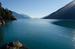
Bute Inlet[1] is one of the principal inlets of the British Columbia Coast. It is 80 km (50 mi) long from the estuaries of the Homathko and Southgate Rivers at the head of the inlet, to the mouth, where it is nearly blocked by Stuart Island, and it averages about 4 km (2.5 mi) in width. Bute Inlet is in a spectacular wilderness setting and is one of the most scenic waterways in the world. In the upper reaches of the inlet mountains rise 2,700 m (9,000 ft) feet above sea level. Bute Inlet is a spectacular wilderness that is visited by very few people. In more recent years tourists are travelling from around the world to view grizzly bears in a natural setting and explore the wilderness of Bute Inlet.
- ^ "Bute Inlet". Geographical Names Data Base. Natural Resources Canada. Retrieved 2020-06-16.
© MMXXIII Rich X Search. We shall prevail. All rights reserved. Rich X Search
