Back Buzzards Bay (luuk) CEB Buzzards Bay German Bahía de Buzzards Spanish Buzzards badia Basque Baie de Buzzards French Baía de Buzzards Galician Baia di Buzzards Italian バザーズ湾 Japanese Баззардс (залив) Russian Buzzards Bay SIMPLE
| Buzzards Bay | |
|---|---|
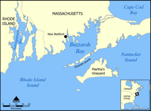
 Map of Buzzards Bay | |
| Location | Massachusetts |
| Coordinates | 41°36′N 70°45′W / 41.600°N 70.750°W |
| Etymology | Named after osprey that were mistakenly called "buzzards" |
| Part of | Atlantic Ocean |
| Max. length | 28 mi (45 km)[1] |
| Max. width | 8 mi (13 km)[1] |
| Surface area | 250 sq mi (650 km2)[1] |
| Average depth | 36 ft (11 m)[1] |
| Settlements | New Bedford, Massachusetts |

Buzzards Bay is a bay of the Atlantic Ocean adjacent to the U.S. state of Massachusetts. It is approximately 28 miles (45 kilometers) long by 8 miles (12 kilometers) wide. It is a popular destination for fishing, boating, and tourism. Buzzards Bay is often considered the finest sailing location on the East Coast and is frequently compared in terms of sailing conditions to San Francisco Bay. Since 1914, Buzzards Bay has been connected to Cape Cod Bay by the Cape Cod Canal. In 1988, under the Clean Water Act, the Environmental Protection Agency and the Commonwealth of Massachusetts designated Buzzards Bay to the National Estuary Program, as "an estuary of national significance" that is threatened by pollution, land development, or overuse.[2]
- ^ a b c d "Buzzards Bay Quick Facts". Buzzards Bay National Estuary Program. Archived from the original on November 16, 2016. Retrieved November 8, 2016.
- ^ "The Environmental Protection Agency and the Massachusetts Executive Office of Environmental Affairs Designate BUZZARDS BAY to the National Estuary Program" (PDF). Buzzards Bay National Estuary Program. 29 January 1988. Archived from the original (PDF) on 22 July 2012. Retrieved 1 June 2012.
© MMXXIII Rich X Search. We shall prevail. All rights reserved. Rich X Search
