Back Caballito CEB Caballito (Buenos Aires) German Caballito Esperanto Caballito Spanish Caballito (Buenos Aires) Basque Caballito French Caballito, Buenos Aires Galician Caballito Italian カバジート Japanese Caballito (Bonaëropolis) Latin
Caballito | |
|---|---|
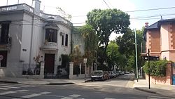
 Residential area of Caballito | |
 Emblem[1] | |
 Location of Caballito within Buenos Aires | |
| Country | Argentina |
| Autonomous City | Buenos Aires |
| Comuna | C6 |
| Important sites | Ferro Carril Oeste, Buenos Aires Heritage Tramway, Parque Centenario |
| Area | |
| • Total | 7.1 km2 (2.7 sq mi) |
| Population (2022)[2] | |
| • Total | 203,784 |
| • Density | 29,000/km2 (74,000/sq mi) |
| Time zone | UTC-3 (ART) |
Caballito (pronounced [kaβaˈʝito]; Spanish for "little horse") is a barrio (neighborhood) of the Argentine capital, Buenos Aires. It is the only barrio in the administrative division Comuna 6.
It is located in the geographical centre of the city, limited by the following streets and avenues: Rio de Janeiro, Av. Rivadavia, Av. La Plata, Av. Directorio, Curapaligüe, Av. Donato Álvarez, Av. Juan B. Justo, Av. San Martín, and Av. Ángel Gallardo.
The name is said to come from the horse-shaped (Spanish caballo) weather vane from a local pulpería (gauchos' bar); Caballito meaning "Little horse".
- ^ "The emblems of the 48 barrios of Buenos Aires were presented" (Spanish) by ámbito.com 29 August 2011
- ^ "Censo Nacional de Población, Hogares y Viviendas 2022" (PDF). Retrieved 29 September 2023.
© MMXXIII Rich X Search. We shall prevail. All rights reserved. Rich X Search