| Cable Creek | |
|---|---|
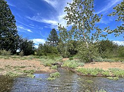
 Cable Creek mouth at the Spokane River | |
| Location | |
| Country | United States |
| State | Washington, Idaho |
| County | Kootenai, Spokane |
| Physical characteristics | |
| Source | Cable Peak |
| • location | Kootenai County, Idaho |
| • coordinates | 47°37′29″N 117°00′44″W / 47.62472°N 117.01222°W[1] |
| • elevation | 4,557 ft (1,389 m) |
| Mouth | Spokane River at |
• location | Liberty Lake, Washington |
• coordinates | 47°41′26″N 117°03′56″W / 47.69056°N 117.06556°W[1] |
• elevation | 2,024 ft (617 m) |
| Length | 9.1 mi (14.6 km)[2] |
| Basin features | |
| Progression | Spokane River → Columbia River → Pacific Ocean |
| River system | Columbia River |
Cable Creek is a stream of approximately 9 miles (14 km) which rises in the U.S. state of Idaho and has its mouth across the state line in Washington. A tributary of the Spokane River that flows from the forested slopes of Mica Peak into the suburban Spokane Valley just east of the city of Liberty Lake.
- ^ a b "Cable Creek". Geographic Names Information System. United States Geological Survey, United States Department of the Interior.
- ^ "Cable Creek". idaho.gov. Idaho Department of Fish and Game. Retrieved 9 June 2024.
© MMXXIII Rich X Search. We shall prevail. All rights reserved. Rich X Search


