Back Каниаписко (язовир) Bulgarian Réservoir de Caniapiscau CEB Caniapiscau-Stausee German Rezervujo Caniapiscau Esperanto Embalse de Caniapiscau Spanish Réservoir de Caniapiscau French Bacino di Caniapiscau Italian კანიაპისკოს წყალსაცავი Georgian Kaniapisko ūdenskrātuve Latvian/Lettish Reservatório de Caniapiscau Portuguese
This article appears to contradict the article List of reservoirs by volume. (September 2019) |
You can help expand this article with text translated from the corresponding article in French. (June 2014) Click [show] for important translation instructions.
|
| Caniapiscau Reservoir | |
|---|---|
 | |
| Location | Caniapiscau / Baie-James, Quebec, Canada |
| Coordinates | 54°09′27″N 69°50′44″W / 54.15750°N 69.84556°W |
| Type | Artificial |
| Primary inflows | Caniapiscau River |
| Primary outflows | Laforge River, Caniapiscau River |
| Catchment area | 36,800 km2 (14,200 sq mi) |
| Basin countries | Canada |
| Max. length | 120 km (75 mi) |
| Max. width | 135 km (84 mi) |
| Surface area | 4,318 km2 (1,667 sq mi) |
| Max. depth | 49 m (161 ft) |
| Water volume | 53.8 km3 (12.9 cu mi)[1] |
| Residence time | 2.2 years |
| Shore length1 | 4,850 km (3,010 mi) |
| Surface elevation | 535 m (1,755 ft) |
| Islands | 300 |
| Settlements | Caniapiscau |
| 1 Shore length is not a well-defined measure. | |
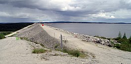
The Caniapiscau Reservoir (French: Réservoir de Caniapiscau) is a reservoir on the upper Caniapiscau River in the Côte-Nord administrative region of the Canadian province of Quebec. It is the largest body of water in Quebec[2] and the second largest reservoir in Canada.
The Caniapiscau Reservoir, formed by two dams and forty-three dikes, is the largest reservoir in surface area of the James Bay Project. As headpond, it feeds the power plants of the La Grande complex in the winter and provides up to 35% of their production.[2] Its total catchment area is about 36,800 square kilometres (14,200 sq mi).
The reservoir was named after Lake Caniapiscau that was flooded during the formation of the reservoir. The name is an adaptation of the Cree or Innu toponym kâ-neyâpiskâw, which means "rocky point". Albert Peter Low had noted in 1895 that "a high rocky headland jutts into the lake." He probably referred to the northwest facing peninsula that gives the reservoir the shape of an arc as we currently know it.[2]
The Caniapiscau Reservoir is accessible by bush plane and, since 1981, by a gravel road from James Bay (the Trans-Taiga Road). At the very end of this road, near the Duplanter spillway, is the former worksite of the Société d'énergie de la Baie-James, named Caniapiscau. There is no permanent human habitation at the reservoir, but it is used by outfitters for seasonal hunting and fishing expeditions and by some Cree for subsistence fishing and trapping.[3] It is isolated from society and there are very few gas stations or other services nearby.
- ^ Cinq principaux réservoirs d'Hydro-Québec
- ^ a b c "Réservoir de Caniapiscau" (in French). Commission de toponymie du Québec. Retrieved 2010-10-07.
- ^ "Caniapiscau Reservoir". World Lakes Database. International Lake Environment Committee. Archived from the original on 2010-05-29. Retrieved 2010-10-08.
© MMXXIII Rich X Search. We shall prevail. All rights reserved. Rich X Search
