Back Cape Peron (punta sa Ostralya, State of Western Australia) CEB Kaap Peron (Rockingham) Dutch Cape Peron (udde i Australien, Western Australia) Swedish
Cape Peron | |
|---|---|
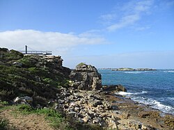
 Looking south at Cape Peron and Shoalwater Islands Marine Park | |
| Coordinates: 32°15′55″S 115°41′10″E / 32.26528°S 115.68611°E | |
| Location | Rockingham, Western Australia |
Cape Peron is a headland at Rockingham, at the southern end of Cockburn Sound in Western Australia. The cape is locally known as Point Peron,[1] and is noted for its protected beaches, limestone cliffs, reefs and panoramic views. Cape Peron includes the suburb of Peron, and "Point Peron" is the designation of a minor promontory on the south side of the cape's extremity.
The feature was named after the French naturalist and zoologist François Péron,[2] who accompanied the expedition of Nicolas Baudin along the western coast of Australia in 1801.
A causeway was constructed in 1973 between Cape Peron and Garden Island to carry vehicular traffic between the mainland and the island. Since the island houses HMAS Stirling, a Royal Australian Navy base, access is restricted by the military.[3]
The wreck of RMS Orizaba (1886–1905) lies on Five Fathom Bank, 5.5 kilometres (3.4 mi) west of the cape.[4]
- ^ Rockingham Parks and Wildlife: Point Peron Archived 24 February 2011 at the Wayback Machine at Rockingham-tourism.com
- ^ Marchant, Leslie R.; Reynolds, J. H. "Péron, François (1775–1810)". Australian Dictionary of Biography. Canberra: National Centre of Biography, Australian National University. Retrieved 9 February 2022.
- ^ Wynne, Emma (30 July 2019). "WA's Garden Island is not just a naval base, it's an ark for rare species and keeper of colonial history". ABC News. Retrieved 5 November 2021.
- ^ "R.M.S. Orizaba". Sydney Morning Herald. 18 February 1905. p. 11. Retrieved 5 November 2021 – via Trove.
© MMXXIII Rich X Search. We shall prevail. All rights reserved. Rich X Search
