Central Arnhem Road | |
|---|---|
 | |
| Central Arnhem Road NT | |
| General information | |
| Type | Road |
| Length | 663 km (412 mi) |
| Route number(s) | |
| Major junctions | |
| Southwest end | |
| Northeast end | Melville Bay Road, Gove Airport, 12 km (7.5 mi) S Nhulunbuy |
| Location(s) | |
| Major suburbs | Barunga, Beswick, Bulman |
| ---- | |
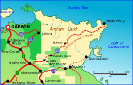
The Central Arnhem Road, also referred to as the Central Arnhem Highway or locally as "The Track", is a designated state route in the Northern Territory of Australia linking the Stuart Highway to the town of Nhulunbuy on the Gove Peninsula and communities across the East Arnhem region. It connects over 12,000 residents and is a key tourism drive and freight route for the mining and pastoral industries.[1]
The route traverses through Aboriginal Land and passes through the Aboriginal communities of Barunga, Beswick and Bulman. A free permit from the Northern Land Council is required for non-indigenous persons to travel its length.
Australian 4WD Action ranked the drive 5th in its list of 20 "must drive" four-wheel drive tracks in Australia in 2010.[2]
- ^ NT Infrastructure Plan and Pipeline 2022 (PDF). Infrastructure NT. 2022.
 Text was copied from this source, which is available under a Creative Commons Attribution 4.0 International License.
- ^ "20 Tracks You Must Drive". Australian 4WD Action. 30 November 2010. Archived from the original on 10 January 2015. Retrieved 10 January 2015.
© MMXXIII Rich X Search. We shall prevail. All rights reserved. Rich X Search
