Back حصن سان لورينزو ARZ Fort de San Lorenzo Catalan San Lorenzo (Panama) Danish Fuerte de San Lorenzo Spanish Chagres et Fort San Lorenzo French מצודת סן לורנסו HE San Lorenzo (Panama) Croatian Forte San Lorenzo Italian სან-ლორენსოს ციხესიმაგრე Georgian Fort San Lorenzo Dutch
Chagres | |
|---|---|
Depopulated village | |
![The current ruins of Fort San Lorenzo date from the 1750s.[1]](http://upload.wikimedia.org/wikipedia/commons/thumb/4/43/Toma_a%C3%A9rea_del_Fuerte_San_Lorenzo.jpg/295px-Toma_a%C3%A9rea_del_Fuerte_San_Lorenzo.jpg) The current ruins of Fort San Lorenzo date from the 1750s.[1] | |
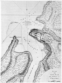
 Map of Chagres and Fort San Lorenzo in about 1739 | |
| Coordinates: 9°19′20″N 80°00′10″W / 9.32222°N 80.00278°W | |
| Country | Panama |
| Province | Colón |
| District | Chagres |
| Established | 1680s |
| Depopulated | 1916 |
| Fort San Lorenzo | |
|---|---|
Fuerte de San Lorenzo, Castillo de San Lorenzo de Chagres | |
| Chagres, Panama | |
 Fort San Lorenzo. 2009 | |
| Site history | |
| Built | 1587 - 1750 |
| Built by | Spain |
| Official name | Fortifications on the Caribbean Side of Panama: Portobelo-San Lorenzo |
| Type | Cultural |
| Criteria | i, iv |
| Designated | 1980 (4th session) |
| Reference no. | 135 |
| Region | Latin America and the Caribbean |
Chagres (Spanish pronunciation: [ˈtʃaɣɾes]), once the chief Atlantic port on the isthmus of Panama, is now an abandoned village at the historical site of Fort San Lorenzo (Spanish: Fuerte de San Lorenzo). The fort's ruins and the village site are located about 8 miles (13 km) west of Colón, on a promontory overlooking the mouth of the Chagres River.
- ^ Weaver and Bauer, p. 88
© MMXXIII Rich X Search. We shall prevail. All rights reserved. Rich X Search
