Back Chatburn CEB Chatburn Welsh Chatburn Spanish Chatburn French Chatburn Italian Chatburn LLD Chatburn Dutch Chatburn Polish Chatburn Swedish Chatburn Turkish
| Chatburn | |
|---|---|
 Chatburn | |
Location within Lancashire | |
| Population | 1,102 (2011)[1] |
| OS grid reference | SD765445 |
| Civil parish |
|
| District | |
| Shire county | |
| Region | |
| Country | England |
| Sovereign state | United Kingdom |
| Post town | CLITHEROE |
| Postcode district | BB7 |
| Dialling code | 01200 |
| Police | Lancashire |
| Fire | Lancashire |
| Ambulance | North West |
| UK Parliament | |
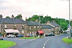
Chatburn is a village, civil parish and electoral ward in the Ribble Valley, East Lancashire, England. The population of the civil parish at the 2011 census was 1,102.[1] Situated in a hollow between two ridges north-east of Clitheroe, just off the A59 road, relatively near Pendle Hill south-east of the village. Lanehead quarry is situated to the West at the termination of Chatburn Old Road. Ribble lane at 240 above sea level leads down to the River Ribble North of the village, the top of Downham road being 150 feet higher.
The parish adjoins the Ribble Valley parishes of Grindleton, Sawley, Rimington, Downham, Worston, Clitheroe and West Bradford.
- ^ a b UK Census (2011). "Local Area Report – Chatburn Parish (1170215100)". Nomis. Office for National Statistics. Retrieved 23 February 2018.
© MMXXIII Rich X Search. We shall prevail. All rights reserved. Rich X Search

