Back مديرية جاتجام Arabic চট্টগ্রাম জেলা Bengali/Bangla চট্টগ্রাম জিলা BPY Districte de Chittagong Catalan Chittagong (distrito) CEB Chittagong (Distrikt) German Chittagong (zila) Spanish ناحیه چیتاگونگ Persian Chittagongin piirikunta Finnish Chittagong (district) French
This article needs additional citations for verification. (June 2008) |
Chittagong District
চট্টগ্রাম জেলা | |
|---|---|
| Chattogram District | |
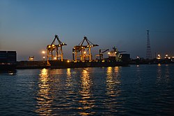
Clockwise from top-left: View of Agrabad, Anderkilla Shahi Jame Mosque, Mahamaya Lake, Port of Chittagong, Chandranath Temple at Sitakunda | |
 | |
 Expandable map of Chittagong District | |
| Coordinates: 22°20′15″N 91°50′20″E / 22.3375°N 91.8389°E | |
| Country | |
| Division | Chittagong Division |
| Seat | Chittagong |
| Government | |
| • Divisional Commissioner | Md. Tofayel Islam |
| • Deputy Commissioner | Abul Bashar Mohammad Fakhruzzaman |
| • District Council Chairman | A.T.M. Pearul Islam |
| Area | |
| • Total | 5,282.92 km2 (2,039.75 sq mi) |
| • Rank | 2 |
| Population (2022 census)[1] | |
| • Total | 9,169,464 |
| • Rank | 2 |
| • Density | 1,700/km2 (4,500/sq mi) |
| Time zone | UTC+06:00 (BST) |
| HDI (2019) | 0.654[2] medium · 3rd of 20 |
| Website | chittagong |
Chittagong District, renamed the Chattogram District,[3] is a district located in south-eastern Bangladesh. It is a part of the Chittagong Division. The port city of Chittagong, which is the second largest city in Bangladesh, is located within this district.
- ^ Population and Housing Census 2022: Preliminary Report. Bangladesh Bureau of Statistics. August 2022. pp. viii, 29, 38, 45. ISBN 978-984-35-2977-0.
- ^ "Sub-national HDI - Area Database - Global Data Lab". hdi.globaldatalab.org. Retrieved 18 March 2020.
- ^ Mahadi Al Hasnat (2 April 2018). "Mixed reactions as govt changes English spellings of 5 district names". Dhaka Tribune. Retrieved 8 April 2018.
© MMXXIII Rich X Search. We shall prevail. All rights reserved. Rich X Search


