Parts of this article (those related to the notable landmarks of a Canadian neighborhood) need to be updated. The reason given is: Requires update per P:WP.. (March 2023) |
CityPlace | |
|---|---|
Neighbourhood | |
 View of western CityPlace (2022) | |
 Vicinity | |
| Coordinates: 43°38′24″N 79°23′43″W / 43.640044°N 79.395179°W | |
| Country | Canada |
| Province | Ontario |
| City | Toronto |
| Government | |
| • MP | Kevin Vuong (Spadina—Fort York) |
| • MPP | Chris Glover (Spadina—Fort York) |
| • Councillor | Ausma Malik (Ward 10 Spadina—Fort York) |
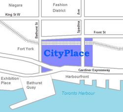
CityPlace is a neighbourhood in Downtown Toronto, Ontario, Canada, within the former Railway Lands. When completed, this area will be the largest residential development ever created in Toronto. The area is bordered by Bathurst Street to the west, Lake Shore Boulevard to the south, and Front Street to the north and Blue Jays Way and Rogers Centre to the east. Cityplace is also a five-to-ten-minute walk from King Street West and Liberty Village and a ten-to-twenty-minute walk from Toronto's financial district. The neighbourhood is also home to the Canoe Landing Park, designed by famed Canadian writer and artist Douglas Coupland.
© MMXXIII Rich X Search. We shall prevail. All rights reserved. Rich X Search

