Back Siti-of-Solford Azerbaijani سالفورد AZB Salford Breton City and Borough of Salford CEB Dinas Salford Welsh City of Salford Danish City of Salford German Ciudad de Salford Spanish Salford Basque سالفورد Persian
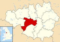
Salford (/ˈsɒlfərd/ SOL-fərd),[7] also known as the City of Salford, is a metropolitan borough with city status in Greater Manchester, England. The borough is named after its main settlement, Salford, but covers a larger area which includes the towns of Eccles, Swinton, Walkden and Pendlebury. [8] The borough had a population of 278,064 in 2022,[4] and is administered from the Salford Civic Centre in Swinton.
Salford is the historic centre of the Salford Hundred an ancient subdivision of Lancashire. The City of Salford is the fifth-most populous district in Greater Manchester.[4] The city's boundaries, set by the Local Government Act 1972, include five former local government districts. It is bounded on the southeast by the River Irwell, which forms part of its boundary with Manchester to the east, and by the Manchester Ship Canal to the south, which forms its boundary with Trafford. The metropolitan boroughs of Wigan, Bolton, and Bury lie to the west, northwest, and north respectively. Some parts of the city, which lies directly west of Manchester, are highly industrialised and densely populated, but around one-third of the city consists of rural open space. The western half of the city stretches across an ancient peat bog, Chat Moss.
Salford has a history of human activity stretching back to the Mesolithic age. There are over 250 listed buildings in the city, including Salford Cathedral, and three Scheduled Ancient Monuments. With the Industrial Revolution, Salford and its neighboring settlements grew alongside the textile industry. The former County Borough of Salford was granted city status in 1926 and thus making it the second city in Greater Manchester after neighbouring Manchester. The city and its industries experienced a decline throughout much of the 20th century. Since the 1990s, parts of Salford have undergone regeneration, especially Salford Quays, home of BBC North and Granada Television, and the area around the University of Salford.
Salford Red Devils are a professional rugby league club in Super League and Salford City F.C. is a professional football club in League Two.
- ^ a b "Salford, North West". Ordnance Survey. Retrieved 16 January 2024.
- ^ "Your Council". Salford City Council. Retrieved 9 January 2024.
- ^ "Mid-Year Population Estimates, UK, June 2022". Office for National Statistics. 26 March 2024. Retrieved 3 May 2024.
- ^ a b c "Mid-Year Population Estimates, UK, June 2022". Office for National Statistics. 26 March 2024. Retrieved 3 May 2024.
- ^ a b UK Census (2021). "2021 Census Area Profile – Salford Local Authority (E08000006)". Nomis. Office for National Statistics. Retrieved 9 January 2024.
- ^ a b Fenton, Trevor (25 April 2023). "Regional gross domestic product: city regions". Office for National Statistics. Retrieved 2 September 2023.
- ^ "Local Authority Districts, Counties and Unitary Authorities (April 2021) Map in United Kingdom". Office for National Statistics: Open Geography Portal. Retrieved 1 August 2023.
- ^ United Kingdom Census 2001. "Greater Manchester Urban Area". statistics.gov.uk. Archived from the original on 5 February 2009. Retrieved 6 December 2007.
{{cite web}}: CS1 maint: numeric names: authors list (link)
© MMXXIII Rich X Search. We shall prevail. All rights reserved. Rich X Search


