Back نهر كلارنس Arabic نهر كلارينس ARZ Clarence River (suba sa Ostralya, State of New South Wales, lat -29,42, long 153,37) CEB Clarence River (Tasmansee) German Río Clarence Spanish Clarence River (Australie) French Clarence (rivier) Dutch Clarence (rzeka w Australii) Polish Clarence River Swedish
| Clarence River Big River[1] | |
|---|---|
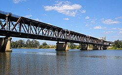
 The Grafton Bridge across the Clarence River. | |
| Etymology | Duke of Clarence[1] |
| Native name |
|
| Location | |
| Country | Australia |
| State | New South Wales |
| Region | NSW North Coast (IBRA), Northern Rivers |
| Local government areas | Kyogle, Clarence Valley |
| City | Grafton |
| Physical characteristics | |
| Source | Border Ranges |
| • location | near Tooloom National Park and Bonalbo |
| • elevation | 252 m (827 ft) |
| 2nd source | Maryland River |
| Mouth | Coral Sea, South Pacific Ocean |
• location | near Iluka and Yamba |
• coordinates | 29°25′32.6″S 153°21′19.4″E / 29.425722°S 153.355389°E |
| Length | 394 km (245 mi) |
| Basin size | 22,850 km2 (8,820 sq mi) |
| Discharge | |
| • average | 160 m3/s (5,700 cu ft/s) |
| • minimum | 1 m3/s (35 cu ft/s) |
| • maximum | 20,000 m3/s (710,000 cu ft/s) |
| Basin features | |
| Tributaries | |
| • left | Nymboida River, Mann River, Tooloom Creek, Cataract River, Orara River, Esk River |
| • right | Coldstream River, Timbarra River |
| River islands | Woodford Island, Chatsworth Island, and Harwood Island |
| [4] | |
The Clarence River (Bundjalung: Boorimbah,[2] Yaygir: Ngunitiji[3]) is a river situated in the Northern Rivers district of New South Wales, Australia. It rises on the eastern slopes of the Great Dividing Range, in the Border Ranges west of Bonalbo, near Rivertree at the junction of Koreelah Creek and Maryland River, on the watershed that marks the border between New South Wales and Queensland. It flows generally south, south east and north east, and is joined by twenty-four tributaries including Tooloom Creek and the Mann, Nymboida, Cataract, Orara, Coldstream, Timbarra, and Esk rivers. It descends 256 metres (840 ft) over the course of its 394-kilometre (245 mi) length and empties into the Coral Sea in the South Pacific Ocean, between Iluka and Yamba.[4]
On its journey it passes through the towns of Tabulam and Copmanhurst, the city of Grafton, and the towns of Ulmarra, and Maclean. The river features many large river islands, including Woodford, Chatsworth, Ashby, Warregah and Harwood islands; and Susan Island Nature Reserve. The river supports a large prawn trawling and fishing industry.
The Clarence River system is an extensive east coast drainage with many tributaries of differing size. The 195km Clarence Canoe and Kayak Trail is the longest mapped whitewater trail in Australia.[citation needed] Its basin is, together with the very similarly-sized Hawkesbury, Australia's largest Pacific watershed south of Bundaberg.[citation needed] The extremely intense rainfalls that typify the North Coast mean, however, that major floods can temporarily raise the flow of the Clarence to 24 feet, as happened in 1890.[5]
- ^ a b "Clarence River". Geographical Names Register (GNR) of NSW. Geographical Names Board of New South Wales. Retrieved 29 January 2013.
- ^ a b Cite error: The named reference
RRHSwas invoked but never defined (see the help page). - ^ a b Barry, Derek. "Crossing the Ngunitiji". Woolly Days. Retrieved 13 October 2018.
- ^ a b "Map of Clarence River". Bonzle.com. Retrieved 29 January 2013.
- ^ "Historical flood information - Clarence Valley Council". www.clarence.nsw.gov.au. Retrieved 18 March 2019.
© MMXXIII Rich X Search. We shall prevail. All rights reserved. Rich X Search