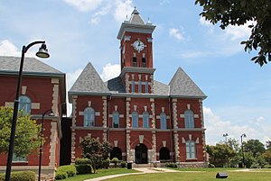
Back مقاطعة كلايتون (جورجيا) Arabic کلایتون بؤلگهسی، جورجیا AZB Clayton County, Georgia BAR Клейтън (окръг, Джорджия) Bulgarian ক্লেটন কাউন্টি, জর্জিয়া BPY Clayton Gông (Georgia) CDO Клейтон (гуо, Джорджи) CE Clayton County (kondado sa Tinipong Bansa, Georgia) CEB Clayton County, Georgia Welsh Clayton County (Georgia) German
Clayton County | |
|---|---|
 | |
 Location within the U.S. state of Georgia | |
 Georgia's location within the U.S. | |
| Coordinates: 33°32′N 84°22′W / 33.54°N 84.36°W | |
| Country | |
| State | |
| Founded | November 30, 1858 |
| Named for | Augustin Smith Clayton |
| Seat | Jonesboro |
| Largest city | Ellenwood |
| Area | |
| • Total | 144 sq mi (370 km2) |
| • Land | 142 sq mi (370 km2) |
| • Water | 2.8 sq mi (7 km2) 1.9% |
| Population | |
| • Estimate (2021) | 297,100 |
| • Density | 2,101/sq mi (811/km2) |
| Time zone | UTC−5 (Eastern) |
| • Summer (DST) | UTC−4 (EDT) |
| Congressional districts | 5th, 13th |
| Website | claytoncountyga.gov |
Clayton County is located in the north central portion of the U.S. state of Georgia. As of 2021, the population was estimated to be 297,100 by the Census Bureau.[1] The county seat is Jonesboro.[2]
Clayton County is included in the Atlanta metropolitan area, and it is the fifth most-populous county in the state. It is the home of most of Hartsfield–Jackson Atlanta International Airport,[3] the busiest airport in the world by total passengers.[4]
- ^ "U.S. Census Bureau QuickFacts: Georgia". U.S. Census Bureau, Population Division. Retrieved July 31, 2022.
- ^ "Find a County". National Association of Counties. Archived from the original on May 31, 2011. Retrieved June 7, 2011.
- ^ "Hartsfield-Jackson Intl Airport Overview and FBOs (Atlanta, GA) [KATL/ATL]". FlightAware. Retrieved January 27, 2019.
- ^ Hunter, Marnie (April 11, 2022). "This US airport has reclaimed its title as the world's busiest". CNN.com.
© MMXXIII Rich X Search. We shall prevail. All rights reserved. Rich X Search

