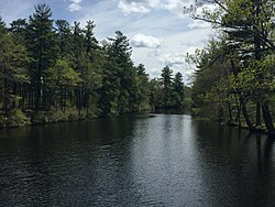
| Cochecho River Cocheco River | |
|---|---|
 The Cochecho at Hanson Pines, Rochester | |
| Location | |
| Country | United States |
| State | New Hampshire |
| County | Strafford |
| Towns & cities | New Durham, Farmington, Rochester, Dover |
| Physical characteristics | |
| Source | |
| • location | New Durham |
| • coordinates | 43°27′34″N 71°6′57″W / 43.45944°N 71.11583°W |
| • elevation | 880 ft (270 m) |
| Mouth | Piscataqua River |
• location | Dover |
• coordinates | 43°10′32″N 70°49′29″W / 43.17556°N 70.82472°W |
• elevation | 0 ft (0 m) |
| Length | 38.3 mi (61.6 km) |
| Basin features | |
| Tributaries | |
| • left | Dames Brook, Blackwater Brook, Fresh Creek |
| • right | Hayes Brook, Ela River, Mad River, Rattlesnake River, Axe Handle Brook, Isinglass River |
The Cochecho River (incorrectly Cocheco River) is a tributary of the Piscataqua River, 38.3 miles (61.6 km) long,[1] in the U.S. state of New Hampshire. It rises in northern Strafford County and runs southeastward, through the town of Farmington and the cities of Rochester and Dover, where it provides hydroelectric power. Below the center of Dover, the river is tidal and joins the Salmon Falls River at the Maine border to form the Piscataqua. Significant tributaries include the Ela River, the Mad River, and the Isinglass River.
© MMXXIII Rich X Search. We shall prevail. All rights reserved. Rich X Search


