Back كولومبيا (مسيسيبي) Arabic كولومبيا (ماريون) ARZ کلمبیا، میسیسیپی AZB Columbia (Mississipi) Catalan Коламбия (Миссисипи) CE Columbia (kapital sa kondado sa Tinipong Bansa, Mississippi) CEB Columbia, Mississippi Welsh Columbia (Misisipi) Spanish Columbia (Mississippi) Basque کلمبیا، میسیسیپی Persian
Columbia, Mississippi | |
|---|---|
 Marion County courthouse in Columbia | |
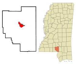
 Location in Marion County and the state of Mississippi | |
| Coordinates: 31°15′24″N 89°49′44″W / 31.25667°N 89.82889°W | |
| Country | United States |
| State | Mississippi |
| County | Marion |
| Government | |
| • Mayor | Justin McKenzie[1] |
| Area | |
| • Total | 6.76 sq mi (17.50 km2) |
| • Land | 6.75 sq mi (17.49 km2) |
| • Water | 0.00 sq mi (0.01 km2) |
| Elevation | 148 ft (45 m) |
| Population | |
| • Total | 5,864 |
| • Density | 868.23/sq mi (335.20/km2) |
| Time zone | UTC-6 (Central (CST)) |
| • Summer (DST) | UTC-5 (CDT) |
| ZIP code | 39429 |
| Area code | 601 |
| FIPS code | 28-15340 |
| GNIS feature ID | 0668715 |
| Website | www |
Columbia is a U.S. city in and the county seat of Marion County, Mississippi,[4] United States. Formed six years before Mississippi was admitted to statehood, Columbia was named for Columbia, South Carolina, from which many of the early settlers had migrated. The population was 5,864 as of the 2020 census,[3] down from 6,582 in 2010.
- ^ "Government Officials". City of Columbia. Retrieved September 10, 2017.
- ^ "2023 U.S. Gazetteer Files: Mississippi". United States Census Bureau. Retrieved February 22, 2024.
- ^ a b "P1. Race – Columbia city, Mississippi: 2020 DEC Redistricting Data (PL 94-171)". U.S. Census Bureau. Retrieved February 22, 2024.
- ^ "Find a County". National Association of Counties. Archived from the original on May 31, 2011.
© MMXXIII Rich X Search. We shall prevail. All rights reserved. Rich X Search


