Back كونيرز Arabic كونيرز ARZ کنیرز، جورجیا AZB Кониърс Bulgarian Conyers Catalan Кониерс (Джорджи) CE Conyers CEB Conyers CH Conyers Czech Conyers, Georgia Welsh
This article needs additional citations for verification. (May 2013) |
Conyers, Georgia | |
|---|---|
City | |
 Olde Town Conyers | |
| Nickname: C-Town | |
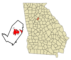
 Location in Rockdale County and the state of Georgia | |
Location of Conyers in Metro Atlanta | |
| Coordinates: 33°39′59″N 84°0′27″W / 33.66639°N 84.00750°W | |
| Country | United States |
| State | Georgia |
| County | Rockdale |
| Area | |
| • Total | 11.88 sq mi (30.78 km2) |
| • Land | 11.76 sq mi (30.46 km2) |
| • Water | 0.12 sq mi (0.32 km2) |
| Elevation | 899 ft (274 m) |
| Population (2020) | |
| • Total | 17,305 |
| • Density | 1,471.51/sq mi (568.14/km2) |
| Time zone | UTC-5 (Eastern (EST)) |
| • Summer (DST) | UTC-4 (EDT) |
| ZIP codes | 30012, 30013, 30094 |
| Area code | 470/678/770 |
| FIPS code | 13-19336[2] |
| GNIS feature ID | 0312910[3] |
| Website | conyersga.com |

Conyers is an Atlanta suburb, the county seat of and only city in Rockdale County, Georgia, United States.[4] The city is 24 miles (38.6 km) east of downtown Atlanta and is a part of the Atlanta Metropolitan Area. As of the 2010 census, the city population was 15,195. The formerly separate town of Milstead is now part of Conyers.
- ^ "2020 U.S. Gazetteer Files". United States Census Bureau. Retrieved December 18, 2021.
- ^ "U.S. Census website". United States Census Bureau. Retrieved January 31, 2008.
- ^ "US Board on Geographic Names". United States Geological Survey. October 25, 2007. Retrieved January 31, 2008.
- ^ "Find a County". National Association of Counties. Archived from the original on May 31, 2011. Retrieved June 7, 2011.
© MMXXIII Rich X Search. We shall prevail. All rights reserved. Rich X Search
