Back مقاطعة كوس (أوريغون) Arabic Coos County, Oregon BAR Кус (окръг, Орегон) Bulgarian কোস কাউন্টি, অরেগন BPY Coos Gông (Oregon) CDO Кус (гуо, Орегон) CE Coos County (kondado sa Tinipong Bansa, Oregon) CEB Coos County (Oregon) Czech Coos County, Oregon Welsh Coos County (Oregon) German
Coos County | |
|---|---|
 | |
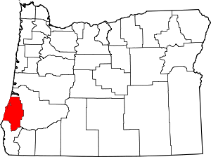
 Location within the U.S. state of Oregon | |
 Oregon's location within the U.S. | |
| Coordinates: 43°11′N 124°05′W / 43.18°N 124.09°W | |
| Country | |
| State | |
| Founded | December 22, 1853 |
| Named for | Coos people |
| Seat | Coquille |
| Largest city | Coos Bay |
| Area | |
| • Total | 1,806 sq mi (4,680 km2) |
| • Land | 1,596 sq mi (4,130 km2) |
| • Water | 210 sq mi (500 km2) 12% |
| Population (2020) | |
| • Total | 64,929 |
| • Estimate (2023) | 64,212 |
| • Density | 39/sq mi (15/km2) |
| Time zone | UTC−8 (Pacific) |
| • Summer (DST) | UTC−7 (PDT) |
| Congressional district | 4th |
| Website | www |
Coos County (/kuːs/ KOOSS) is one of the 36 counties in the U.S. state of Oregon. As of the 2020 census, the population was 64,929.[1] The county seat is Coquille.[2] The county was formed from the western parts of Umpqua and Jackson counties. It is named after a tribe of Native Americans who live in the region. Coos County comprises the Coos Bay, OR Micropolitan Statistical Area.
- ^ "State & County QuickFacts". United States Census Bureau. Retrieved May 17, 2023.
- ^ "Find a County". National Association of Counties. Archived from the original on May 31, 2011. Retrieved June 7, 2011.
© MMXXIII Rich X Search. We shall prevail. All rights reserved. Rich X Search